You are here: Home > Network List > US - United States National Seismic Network Stations List
> Station DUG Dugway, Tooele County, Utah, USA > Earthquake Result Viewer
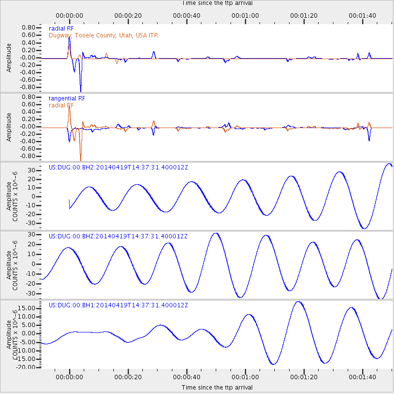
DUG Dugway, Tooele County, Utah, USA - Earthquake Result Viewer
*The percent match for this event was below the threshold and hence no stack was calculated.
| Earthquake location: |
Solomon Islands |
| Earthquake latitude/longitude: |
-7.1/154.9 |
| Earthquake time(UTC): |
2014/04/19 (109) 14:24:38 GMT |
| Earthquake Depth: |
41 km |
| Earthquake Magnitude: |
4.8 mb |
| Earthquake Catalog/Contributor: |
ISC/ISC |
|
| Network: |
US United States National Seismic Network |
| Station: |
DUG Dugway, Tooele County, Utah, USA |
| Lat/Lon: |
40.19 N/112.81 W |
| Elevation: |
1477 m |
|
| Distance: |
96.2 deg |
| Az: |
50.348 deg |
| Baz: |
266.04 deg |
| Ray Param: |
$rayparam |
*The percent match for this event was below the threshold and hence was not used in the summary stack. |
|
| Radial Match: |
96.17631 % |
| Radial Bump: |
265 |
| Transverse Match: |
67.947464 % |
| Transverse Bump: |
400 |
| SOD ConfigId: |
3390531 |
| Insert Time: |
2019-04-11 12:13:18.608 +0000 |
| GWidth: |
2.5 |
| Max Bumps: |
400 |
| Tol: |
0.001 |
|
Signal To Noise
| Channel | StoN | STA | LTA |
| US:DUG:00:BHZ:20140419T14:37:31.400012Z | 1.6832362 | 1.4446068E-5 | 8.582318E-6 |
| US:DUG:00:BH1:20140419T14:37:31.400012Z | 0.3156846 | 1.8375526E-6 | 5.82085E-6 |
| US:DUG:00:BH2:20140419T14:37:31.400012Z | 1.5450132 | 1.5276632E-5 | 9.887703E-6 |
| Arrivals |
| Ps | |
| PpPs | |
| PsPs/PpSs | |


