You are here: Home > Network List > UW - Pacific Northwest Regional Seismic Network Stations List
> Station MRBL Marblemount, WA, USA > Earthquake Result Viewer
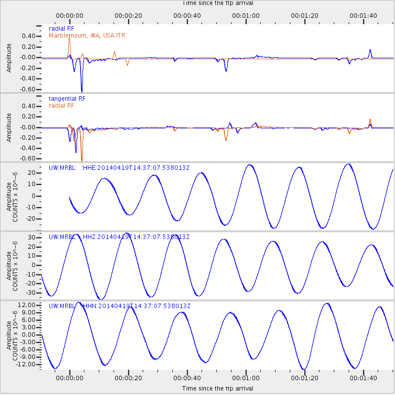
MRBL Marblemount, WA, USA - Earthquake Result Viewer
*The percent match for this event was below the threshold and hence no stack was calculated.
| Earthquake location: |
Solomon Islands |
| Earthquake latitude/longitude: |
-7.1/154.9 |
| Earthquake time(UTC): |
2014/04/19 (109) 14:24:38 GMT |
| Earthquake Depth: |
41 km |
| Earthquake Magnitude: |
4.8 mb |
| Earthquake Catalog/Contributor: |
ISC/ISC |
|
| Network: |
UW Pacific Northwest Regional Seismic Network |
| Station: |
MRBL Marblemount, WA, USA |
| Lat/Lon: |
48.52 N/121.48 W |
| Elevation: |
75 m |
|
| Distance: |
91.0 deg |
| Az: |
41.361 deg |
| Baz: |
260.545 deg |
| Ray Param: |
$rayparam |
*The percent match for this event was below the threshold and hence was not used in the summary stack. |
|
| Radial Match: |
96.31013 % |
| Radial Bump: |
297 |
| Transverse Match: |
95.013245 % |
| Transverse Bump: |
302 |
| SOD ConfigId: |
3390531 |
| Insert Time: |
2019-04-11 12:13:24.487 +0000 |
| GWidth: |
2.5 |
| Max Bumps: |
400 |
| Tol: |
0.001 |
|
Signal To Noise
| Channel | StoN | STA | LTA |
| UW:MRBL: :HHZ:20140419T14:37:07.538013Z | 1.6117778 | 3.0340974E-5 | 1.882454E-5 |
| UW:MRBL: :HHN:20140419T14:37:07.538013Z | 1.2839715 | 1.0518464E-5 | 8.192131E-6 |
| UW:MRBL: :HHE:20140419T14:37:07.538013Z | 1.2443942 | 1.3204918E-5 | 1.0611523E-5 |
| Arrivals |
| Ps | |
| PpPs | |
| PsPs/PpSs | |


