You are here: Home > Network List > G - GEOSCOPE Stations List
> Station HYB Hyderabad, India > Earthquake Result Viewer
HYB Hyderabad, India - Earthquake Result Viewer
| Earthquake location: |
Vanuatu Islands |
| Earthquake latitude/longitude: |
-14.7/167.3 |
| Earthquake time(UTC): |
1996/03/17 (077) 14:48:56 GMT |
| Earthquake Depth: |
164 km |
| Earthquake Magnitude: |
5.8 MB, 6.0 MS, 6.7 UNKNOWN, 6.1 MS |
| Earthquake Catalog/Contributor: |
WHDF/NEIC |
|
| Network: |
G GEOSCOPE |
| Station: |
HYB Hyderabad, India |
| Lat/Lon: |
17.42 N/78.55 E |
| Elevation: |
510 m |
|
| Distance: |
93.1 deg |
| Az: |
287.073 deg |
| Baz: |
104.33 deg |
| Ray Param: |
0.041223887 |
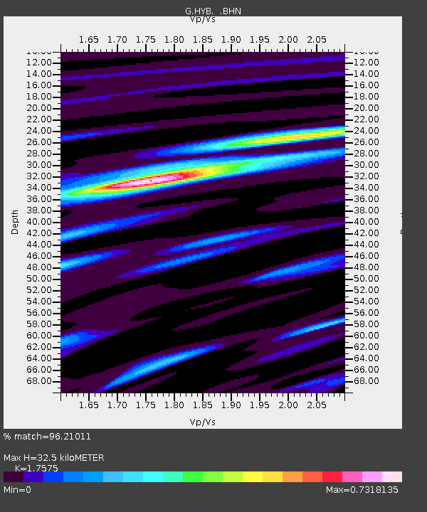
| Estimated Moho Depth: |
32.5 km |
| Estimated Crust Vp/Vs: |
1.76 |
| Assumed Crust Vp: |
6.459 km/s |
| Estimated Crust Vs: |
3.675 km/s |
| Estimated Crust Poisson's Ratio: |
0.26 |
|
| Radial Match: |
96.21011 % |
| Radial Bump: |
397 |
| Transverse Match: |
82.8755 % |
| Transverse Bump: |
400 |
| SOD ConfigId: |
4480 |
| Insert Time: |
2010-02-26 22:55:48.247 +0000 |
| GWidth: |
2.5 |
| Max Bumps: |
400 |
| Tol: |
0.001 |
|
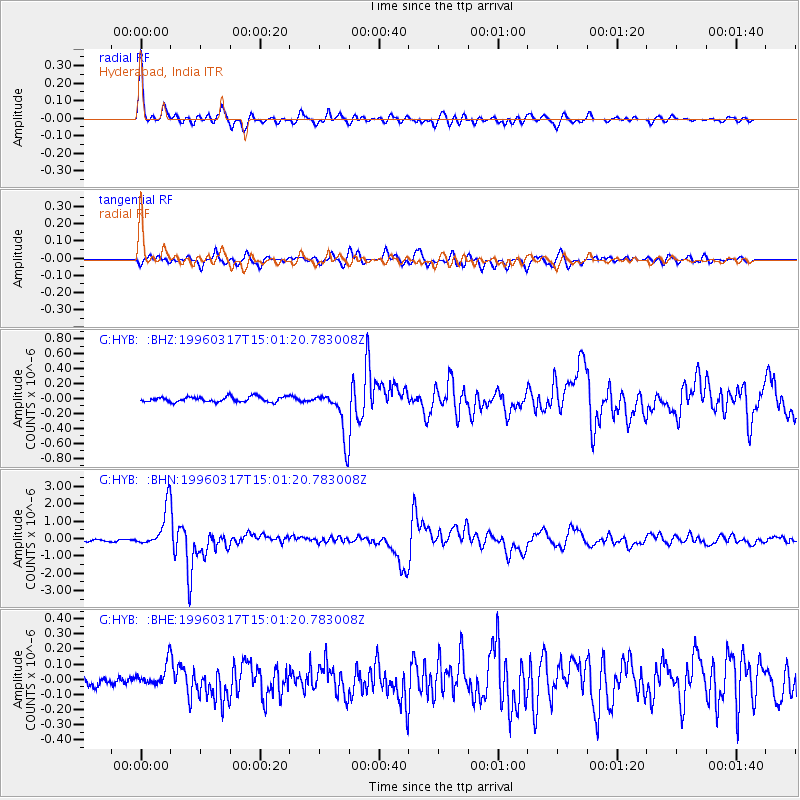
Signal To Noise
| Channel | StoN | STA | LTA |
| G:HYB: :BHN:19960317T15:01:20.783008Z | 13.399567 | 1.1715911E-6 | 8.7435E-8 |
| G:HYB: :BHE:19960317T15:01:20.783008Z | 2.0442524 | 8.212953E-8 | 4.017583E-8 |
| G:HYB: :BHZ:19960317T15:01:20.783008Z | 9.108227 | 3.167778E-7 | 3.4779305E-8 |
| Arrivals |
| Ps | 3.9 SECOND |
| PpPs | 14 SECOND |
| PsPs/PpSs | 17 SECOND |


