You are here: Home > Network List > TA - USArray Transportable Network (new EarthScope stations) Stations List
> Station T35A Sooner Cattle Company, Foraker, OK, USA > Earthquake Result Viewer
T35A Sooner Cattle Company, Foraker, OK, USA - Earthquake Result Viewer
| Earthquake location: |
Near Coast Of Northern Chile |
| Earthquake latitude/longitude: |
-27.9/-70.9 |
| Earthquake time(UTC): |
2011/12/07 (341) 22:23:09 GMT |
| Earthquake Depth: |
20 km |
| Earthquake Magnitude: |
5.8 MB, 5.8 MS, 6.1 MW, 6.0 MW |
| Earthquake Catalog/Contributor: |
WHDF/NEIC |
|
| Network: |
TA USArray Transportable Network (new EarthScope stations) |
| Station: |
T35A Sooner Cattle Company, Foraker, OK, USA |
| Lat/Lon: |
36.92 N/96.51 W |
| Elevation: |
401 m |
|
| Distance: |
68.8 deg |
| Az: |
338.204 deg |
| Baz: |
155.792 deg |
| Ray Param: |
0.056035884 |
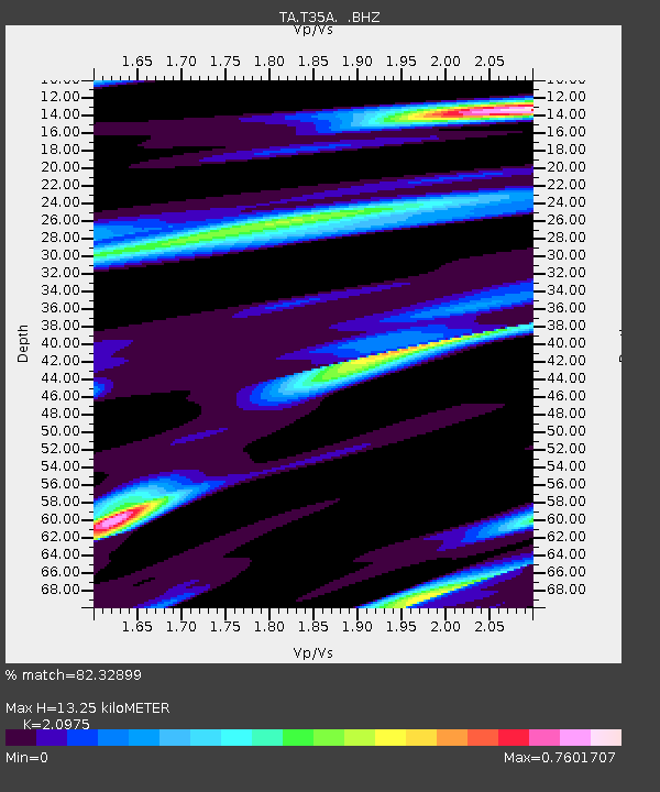
| Estimated Moho Depth: |
13.25 km |
| Estimated Crust Vp/Vs: |
2.10 |
| Assumed Crust Vp: |
6.483 km/s |
| Estimated Crust Vs: |
3.091 km/s |
| Estimated Crust Poisson's Ratio: |
0.35 |
|
| Radial Match: |
82.32899 % |
| Radial Bump: |
400 |
| Transverse Match: |
53.905144 % |
| Transverse Bump: |
400 |
| SOD ConfigId: |
432046 |
| Insert Time: |
2012-03-08 00:33:14.171 +0000 |
| GWidth: |
2.5 |
| Max Bumps: |
400 |
| Tol: |
0.001 |
|
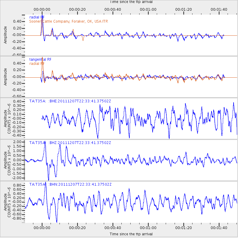
Signal To Noise
| Channel | StoN | STA | LTA |
| TA:T35A: :BHZ:20111207T22:33:41.37502Z | 10.217884 | 1.066252E-6 | 1.0435154E-7 |
| TA:T35A: :BHN:20111207T22:33:41.37502Z | 3.727343 | 4.8245477E-7 | 1.2943663E-7 |
| TA:T35A: :BHE:20111207T22:33:41.37502Z | 2.0798678 | 2.2246667E-7 | 1.0696192E-7 |
| Arrivals |
| Ps | 2.3 SECOND |
| PpPs | 6.1 SECOND |
| PsPs/PpSs | 8.4 SECOND |


