You are here: Home > Network List > TA - USArray Transportable Network (new EarthScope stations) Stations List
> Station J32A Parkston, SD, USA > Earthquake Result Viewer
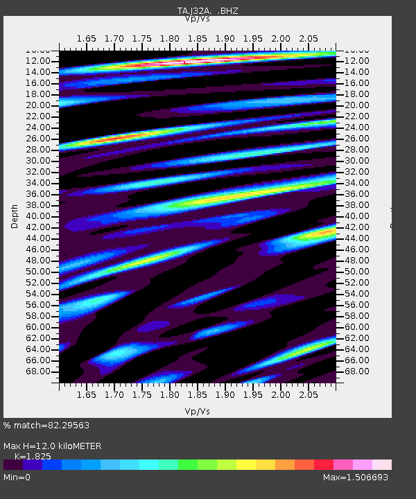
J32A Parkston, SD, USA - Earthquake Result Viewer
| Earthquake location: |
Near Coast Of Northern Chile |
| Earthquake latitude/longitude: |
-27.9/-70.9 |
| Earthquake time(UTC): |
2011/12/07 (341) 22:23:09 GMT |
| Earthquake Depth: |
20 km |
| Earthquake Magnitude: |
5.8 MB, 5.8 MS, 6.1 MW, 6.0 MW |
| Earthquake Catalog/Contributor: |
WHDF/NEIC |
|
| Network: |
TA USArray Transportable Network (new EarthScope stations) |
| Station: |
J32A Parkston, SD, USA |
| Lat/Lon: |
43.37 N/97.85 W |
| Elevation: |
399 m |
|
| Distance: |
75.1 deg |
| Az: |
340.018 deg |
| Baz: |
155.496 deg |
| Ray Param: |
0.051865052 |
| Estimated Moho Depth: |
12.0 km |
| Estimated Crust Vp/Vs: |
1.83 |
| Assumed Crust Vp: |
6.498 km/s |
| Estimated Crust Vs: |
3.56 km/s |
| Estimated Crust Poisson's Ratio: |
0.29 |
|
| Radial Match: |
82.29563 % |
| Radial Bump: |
400 |
| Transverse Match: |
67.56299 % |
| Transverse Bump: |
400 |
| SOD ConfigId: |
432046 |
| Insert Time: |
2012-03-08 00:34:28.447 +0000 |
| GWidth: |
2.5 |
| Max Bumps: |
400 |
| Tol: |
0.001 |
|

Signal To Noise
| Channel | StoN | STA | LTA |
| TA:J32A: :BHZ:20111207T22:34:19.024983Z | 10.201959 | 1.2247954E-6 | 1.2005492E-7 |
| TA:J32A: :BHN:20111207T22:34:19.024983Z | 5.0599113 | 6.777657E-7 | 1.3394813E-7 |
| TA:J32A: :BHE:20111207T22:34:19.024983Z | 3.1284213 | 3.7281808E-7 | 1.1917131E-7 |
| Arrivals |
| Ps | 1.6 SECOND |
| PpPs | 5.1 SECOND |
| PsPs/PpSs | 6.6 SECOND |


