You are here: Home > Network List > TA - USArray Transportable Network (new EarthScope stations) Stations List
> Station F46A Macinaw City Comets, Mackinaw City, MI, USA > Earthquake Result Viewer
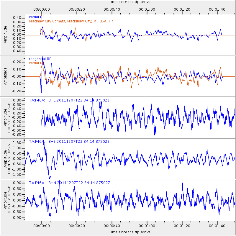
F46A Macinaw City Comets, Mackinaw City, MI, USA - Earthquake Result Viewer
*The percent match for this event was below the threshold and hence no stack was calculated.
| Earthquake location: |
Near Coast Of Northern Chile |
| Earthquake latitude/longitude: |
-27.9/-70.9 |
| Earthquake time(UTC): |
2011/12/07 (341) 22:23:09 GMT |
| Earthquake Depth: |
20 km |
| Earthquake Magnitude: |
5.8 MB, 5.8 MS, 6.1 MW, 6.0 MW |
| Earthquake Catalog/Contributor: |
WHDF/NEIC |
|
| Network: |
TA USArray Transportable Network (new EarthScope stations) |
| Station: |
F46A Macinaw City Comets, Mackinaw City, MI, USA |
| Lat/Lon: |
45.77 N/84.76 W |
| Elevation: |
198 m |
|
| Distance: |
74.4 deg |
| Az: |
349.989 deg |
| Baz: |
167.301 deg |
| Ray Param: |
$rayparam |
*The percent match for this event was below the threshold and hence was not used in the summary stack. |
|
| Radial Match: |
66.15847 % |
| Radial Bump: |
400 |
| Transverse Match: |
62.04969 % |
| Transverse Bump: |
400 |
| SOD ConfigId: |
432046 |
| Insert Time: |
2012-03-08 00:46:29.204 +0000 |
| GWidth: |
2.5 |
| Max Bumps: |
400 |
| Tol: |
0.001 |
|
Signal To Noise
| Channel | StoN | STA | LTA |
| TA:F46A: :BHZ:20111207T22:34:14.87502Z | 2.8063776 | 9.835405E-7 | 3.504662E-7 |
| TA:F46A: :BHN:20111207T22:34:14.87502Z | 1.5791546 | 3.9108562E-7 | 2.4765504E-7 |
| TA:F46A: :BHE:20111207T22:34:14.87502Z | 1.8308561 | 4.275075E-7 | 2.3350142E-7 |
| Arrivals |
| Ps | |
| PpPs | |
| PsPs/PpSs | |


