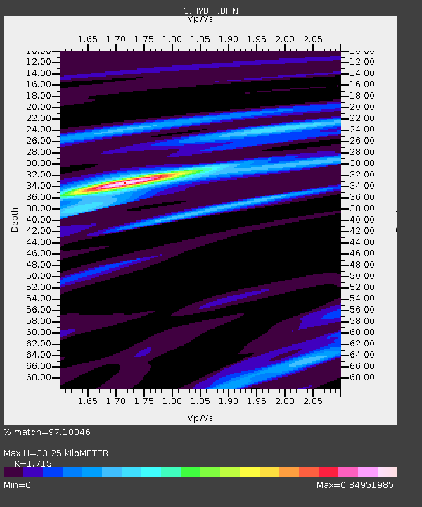
HYB Hyderabad, India - Earthquake Result Viewer
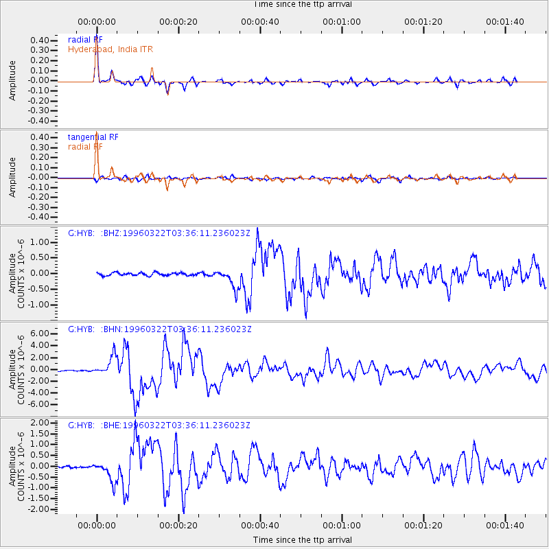
Earthquake location: Rat Islands, Aleutian Islands
Earthquake latitude/longitude: 51.2/178.7
Earthquake time(UTC): 1996/03/22 (082) 03:24:20 GMT
Earthquake Depth: 20 km
Earthquake Magnitude: 5.7 MB, 6.6 MS, 6.8 UNKNOWN, 6.6 ML
Earthquake Catalog/Contributor: WHDF/NEIC
Network: G GEOSCOPE
Station: HYB Hyderabad, India
Lat/Lon: 17.42 N/78.55 E
Elevation: 510 m
Distance: 82.8 deg
Az: 288.683 deg
Baz: 38.608 deg
Ray Param: 0.046628214
Estimated Moho Depth: 33.25 km
Estimated Crust Vp/Vs: 1.72
Assumed Crust Vp: 6.459 km/s
Estimated Crust Vs: 3.766 km/s
Estimated Crust Poisson's Ratio: 0.24
Radial Match: 97.10046 %
Radial Bump: 309
Transverse Match: 89.836525 %
Transverse Bump: 400
SOD ConfigId: 4480
Insert Time: 2010-02-26 22:56:45.813 +0000
GWidth: 2.5
Max Bumps: 400
Tol: 0.001

Signal To Noise

ChannelStoNSTALTA
G:HYB: :BHN:19960322T03:36:11.236023Z28.9501531.6932612E-65.8488855E-8
G:HYB: :BHE:19960322T03:36:11.236023Z13.7941894.9261257E-73.57116E-8
G:HYB: :BHZ:19960322T03:36:11.236023Z7.4177783.2441153E-74.3734328E-8
Arrivals
Ps3.8 SECOND
PpPs14 SECOND
PsPs/PpSs17 SECOND