You are here: Home > Network List > AZ - ANZA Regional Network Stations List
> Station SMER AZ.SMER > Earthquake Result Viewer
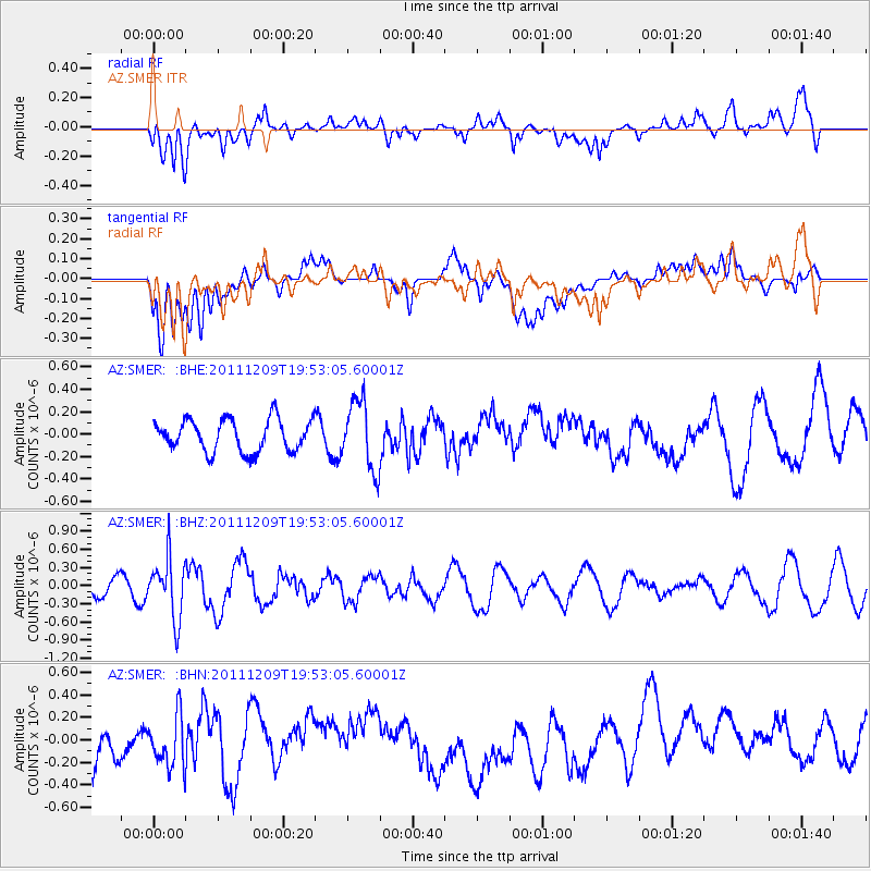
SMER AZ.SMER - Earthquake Result Viewer
*The percent match for this event was below the threshold and hence no stack was calculated.
| Earthquake location: |
Sea Of Okhotsk |
| Earthquake latitude/longitude: |
47.0/144.6 |
| Earthquake time(UTC): |
2011/12/09 (343) 19:42:57 GMT |
| Earthquake Depth: |
392 km |
| Earthquake Magnitude: |
5.7 MB, 5.7 MW, 5.8 MW |
| Earthquake Catalog/Contributor: |
WHDF/NEIC |
|
| Network: |
AZ ANZA Regional Network |
| Station: |
SMER AZ.SMER |
| Lat/Lon: |
33.46 N/117.17 W |
| Elevation: |
355 m |
|
| Distance: |
71.5 deg |
| Az: |
60.75 deg |
| Baz: |
314.421 deg |
| Ray Param: |
$rayparam |
*The percent match for this event was below the threshold and hence was not used in the summary stack. |
|
| Radial Match: |
51.199574 % |
| Radial Bump: |
400 |
| Transverse Match: |
36.23548 % |
| Transverse Bump: |
400 |
| SOD ConfigId: |
432046 |
| Insert Time: |
2012-03-08 01:01:34.603 +0000 |
| GWidth: |
2.5 |
| Max Bumps: |
400 |
| Tol: |
0.001 |
|
Signal To Noise
| Channel | StoN | STA | LTA |
| AZ:SMER: :BHZ:20111209T19:53:05.60001Z | 4.0459747 | 4.9877366E-7 | 1.2327651E-7 |
| AZ:SMER: :BHN:20111209T19:53:05.60001Z | 0.96149355 | 2.3433667E-7 | 2.4372153E-7 |
| AZ:SMER: :BHE:20111209T19:53:05.60001Z | 2.1874192 | 3.089194E-7 | 1.4122551E-7 |
| Arrivals |
| Ps | |
| PpPs | |
| PsPs/PpSs | |


