You are here: Home > Network List > CI - Caltech Regional Seismic Network Stations List
> Station SMM Simmler, CA, USA > Earthquake Result Viewer
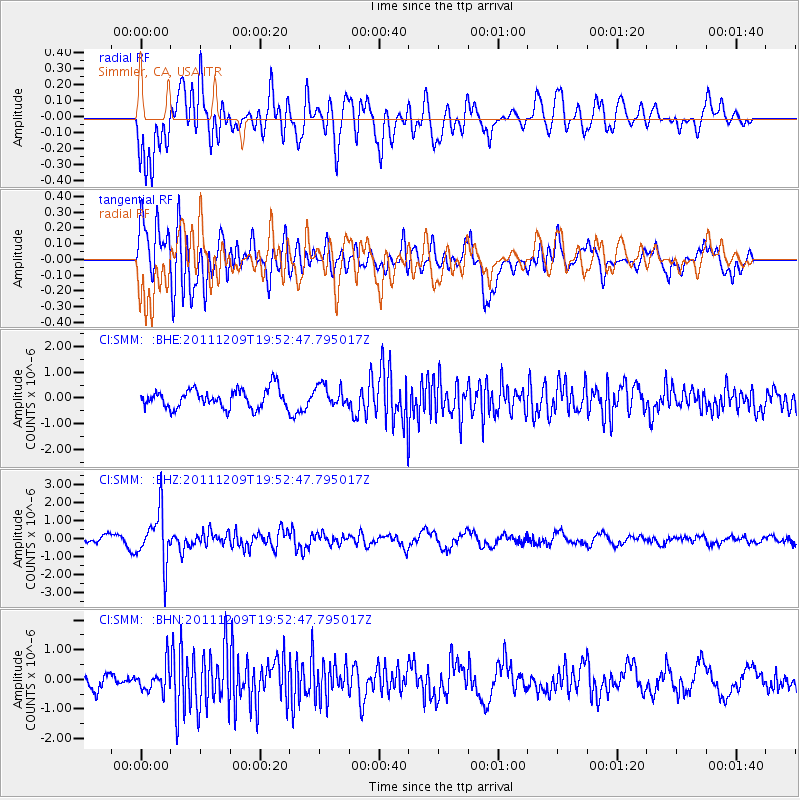
SMM Simmler, CA, USA - Earthquake Result Viewer
*The percent match for this event was below the threshold and hence no stack was calculated.
| Earthquake location: |
Sea Of Okhotsk |
| Earthquake latitude/longitude: |
47.0/144.6 |
| Earthquake time(UTC): |
2011/12/09 (343) 19:42:57 GMT |
| Earthquake Depth: |
392 km |
| Earthquake Magnitude: |
5.7 MB, 5.7 MW, 5.8 MW |
| Earthquake Catalog/Contributor: |
WHDF/NEIC |
|
| Network: |
CI Caltech Regional Seismic Network |
| Station: |
SMM Simmler, CA, USA |
| Lat/Lon: |
35.31 N/120.00 W |
| Elevation: |
599 m |
|
| Distance: |
68.5 deg |
| Az: |
61.042 deg |
| Baz: |
312.932 deg |
| Ray Param: |
$rayparam |
*The percent match for this event was below the threshold and hence was not used in the summary stack. |
|
| Radial Match: |
58.95713 % |
| Radial Bump: |
400 |
| Transverse Match: |
79.6257 % |
| Transverse Bump: |
400 |
| SOD ConfigId: |
432046 |
| Insert Time: |
2012-03-08 01:04:21.170 +0000 |
| GWidth: |
2.5 |
| Max Bumps: |
400 |
| Tol: |
0.001 |
|
Signal To Noise
| Channel | StoN | STA | LTA |
| CI:SMM: :BHZ:20111209T19:52:47.795017Z | 6.021053 | 1.4430934E-6 | 2.396746E-7 |
| CI:SMM: :BHN:20111209T19:52:47.795017Z | 1.3699611 | 4.3636302E-7 | 3.1852218E-7 |
| CI:SMM: :BHE:20111209T19:52:47.795017Z | 1.0982308 | 4.0573082E-7 | 3.694404E-7 |
| Arrivals |
| Ps | |
| PpPs | |
| PsPs/PpSs | |


