You are here: Home > Network List > IW - Intermountain West Stations List
> Station DLMT Dillon, Montana, USA > Earthquake Result Viewer
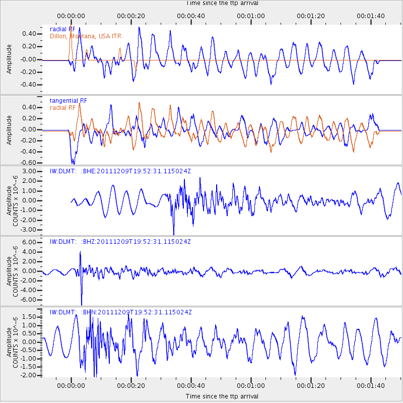
DLMT Dillon, Montana, USA - Earthquake Result Viewer
*The percent match for this event was below the threshold and hence no stack was calculated.
| Earthquake location: |
Sea Of Okhotsk |
| Earthquake latitude/longitude: |
47.0/144.6 |
| Earthquake time(UTC): |
2011/12/09 (343) 19:42:57 GMT |
| Earthquake Depth: |
392 km |
| Earthquake Magnitude: |
5.7 MB, 5.7 MW, 5.8 MW |
| Earthquake Catalog/Contributor: |
WHDF/NEIC |
|
| Network: |
IW Intermountain West |
| Station: |
DLMT Dillon, Montana, USA |
| Lat/Lon: |
45.36 N/112.60 W |
| Elevation: |
1569 m |
|
| Distance: |
65.8 deg |
| Az: |
48.896 deg |
| Baz: |
312.994 deg |
| Ray Param: |
$rayparam |
*The percent match for this event was below the threshold and hence was not used in the summary stack. |
|
| Radial Match: |
76.44861 % |
| Radial Bump: |
400 |
| Transverse Match: |
72.82573 % |
| Transverse Bump: |
400 |
| SOD ConfigId: |
432046 |
| Insert Time: |
2012-03-08 01:08:37.674 +0000 |
| GWidth: |
2.5 |
| Max Bumps: |
400 |
| Tol: |
0.001 |
|
Signal To Noise
| Channel | StoN | STA | LTA |
| IW:DLMT: :BHZ:20111209T19:52:31.115024Z | 4.8070903 | 1.791609E-6 | 3.7270132E-7 |
| IW:DLMT: :BHN:20111209T19:52:31.115024Z | 1.7942934 | 1.0258049E-6 | 5.717041E-7 |
| IW:DLMT: :BHE:20111209T19:52:31.115024Z | 1.2668209 | 1.0004701E-6 | 7.8974864E-7 |
| Arrivals |
| Ps | |
| PpPs | |
| PsPs/PpSs | |


