You are here: Home > Network List > IU - Global Seismograph Network (GSN - IRIS/USGS) Stations List
> Station XMAS Kiritimati Island, Republic of Kiribati > Earthquake Result Viewer
XMAS Kiritimati Island, Republic of Kiribati - Earthquake Result Viewer
*The percent match for this event was below the threshold and hence no stack was calculated.
| Earthquake location: |
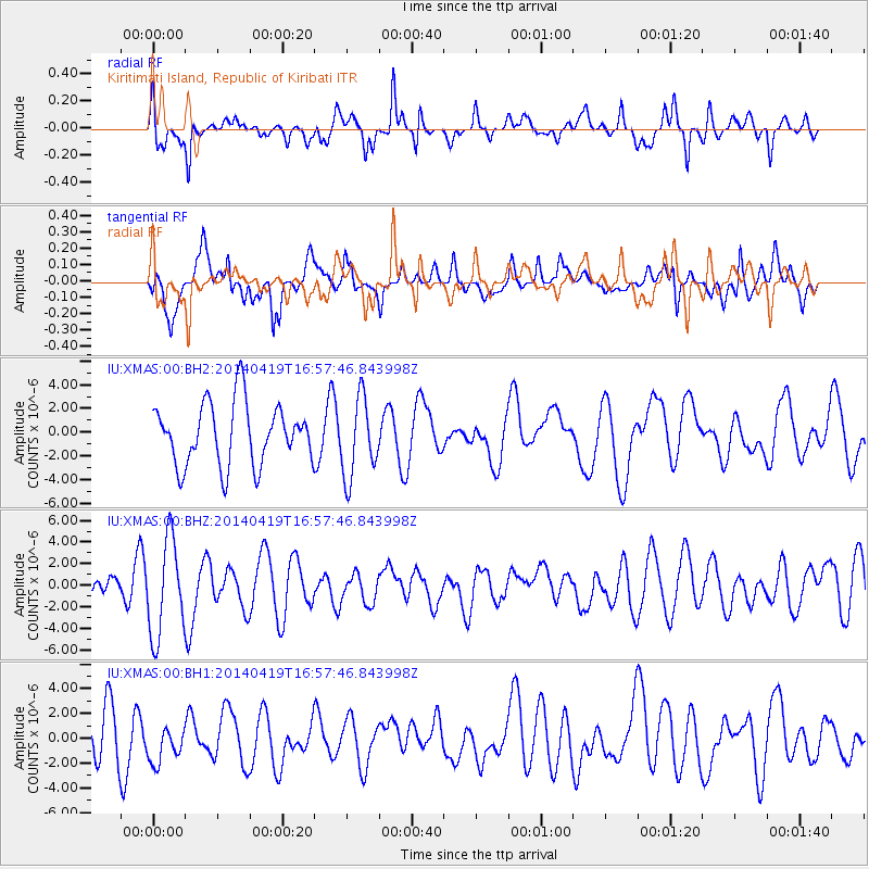
Solomon Islands |
| Earthquake latitude/longitude: |
-7.1/154.9 |
| Earthquake time(UTC): |
2014/04/19 (109) 16:49:39 GMT |
| Earthquake Depth: |
41 km |
| Earthquake Magnitude: |
5.2 mb |
| Earthquake Catalog/Contributor: |
ISC/ISC |
|
| Network: |
IU Global Seismograph Network (GSN - IRIS/USGS) |
| Station: |
XMAS Kiritimati Island, Republic of Kiribati |
| Lat/Lon: |
2.04 N/157.45 W |
| Elevation: |
20 m |
|
| Distance: |
48.4 deg |
| Az: |
80.961 deg |
| Baz: |
258.745 deg |
| Ray Param: |
$rayparam |
*The percent match for this event was below the threshold and hence was not used in the summary stack. |
|
| Radial Match: |
59.562336 % |
| Radial Bump: |
400 |
| Transverse Match: |
63.85019 % |
| Transverse Bump: |
400 |
| SOD ConfigId: |
3390531 |
| Insert Time: |
2019-04-11 12:24:10.704 +0000 |
| GWidth: |
2.5 |
| Max Bumps: |
400 |
| Tol: |
0.001 |
|
Signal To Noise
| Channel | StoN | STA | LTA |
| IU:XMAS:00:BHZ:20140419T16:57:46.843998Z | 2.1685255 | 4.4813405E-6 | 2.0665382E-6 |
| IU:XMAS:00:BH1:20140419T16:57:46.843998Z | 0.71535254 | 1.6162694E-6 | 2.2594027E-6 |
| IU:XMAS:00:BH2:20140419T16:57:46.843998Z | 1.2931384 | 3.358325E-6 | 2.5970346E-6 |
| Arrivals |
| Ps | |
| PpPs | |
| PsPs/PpSs | |


