You are here: Home > Network List > TA - USArray Transportable Network (new EarthScope stations) Stations List
> Station M36A Felix, Anita, IA, USA > Earthquake Result Viewer
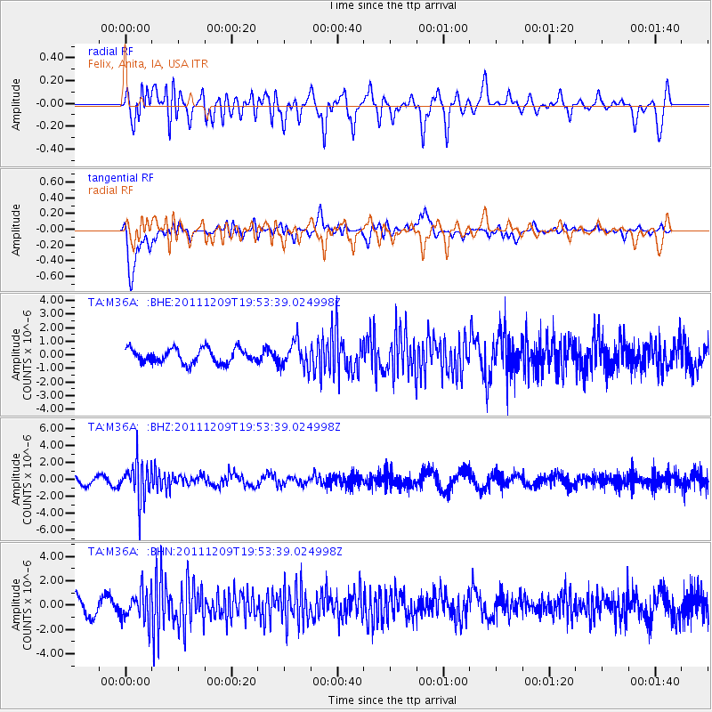
M36A Felix, Anita, IA, USA - Earthquake Result Viewer
*The percent match for this event was below the threshold and hence no stack was calculated.
| Earthquake location: |
Sea Of Okhotsk |
| Earthquake latitude/longitude: |
47.0/144.6 |
| Earthquake time(UTC): |
2011/12/09 (343) 19:42:57 GMT |
| Earthquake Depth: |
392 km |
| Earthquake Magnitude: |
5.7 MB, 5.7 MW, 5.8 MW |
| Earthquake Catalog/Contributor: |
WHDF/NEIC |
|
| Network: |
TA USArray Transportable Network (new EarthScope stations) |
| Station: |
M36A Felix, Anita, IA, USA |
| Lat/Lon: |
41.45 N/94.80 W |
| Elevation: |
430 m |
|
| Distance: |
77.4 deg |
| Az: |
41.509 deg |
| Baz: |
322.89 deg |
| Ray Param: |
$rayparam |
*The percent match for this event was below the threshold and hence was not used in the summary stack. |
|
| Radial Match: |
56.54262 % |
| Radial Bump: |
400 |
| Transverse Match: |
81.8282 % |
| Transverse Bump: |
400 |
| SOD ConfigId: |
432046 |
| Insert Time: |
2012-03-08 01:18:54.058 +0000 |
| GWidth: |
2.5 |
| Max Bumps: |
400 |
| Tol: |
0.001 |
|
Signal To Noise
| Channel | StoN | STA | LTA |
| TA:M36A: :BHZ:20111209T19:53:39.024998Z | 3.8236318 | 2.2370614E-6 | 5.850619E-7 |
| TA:M36A: :BHN:20111209T19:53:39.024998Z | 1.7323807 | 1.2716931E-6 | 7.3407256E-7 |
| TA:M36A: :BHE:20111209T19:53:39.024998Z | 1.8027396 | 9.4994084E-7 | 5.269429E-7 |
| Arrivals |
| Ps | |
| PpPs | |
| PsPs/PpSs | |


