You are here: Home > Network List > TA - USArray Transportable Network (new EarthScope stations) Stations List
> Station L37A Phoenix Point, Boone, IA, USA > Earthquake Result Viewer
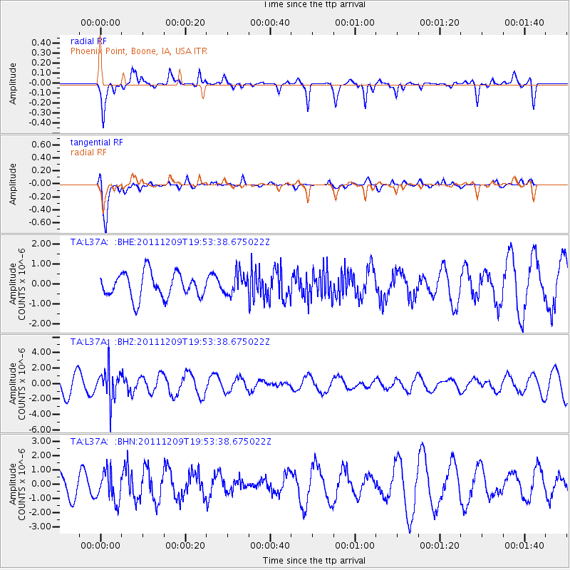
L37A Phoenix Point, Boone, IA, USA - Earthquake Result Viewer
*The percent match for this event was below the threshold and hence no stack was calculated.
| Earthquake location: |
Sea Of Okhotsk |
| Earthquake latitude/longitude: |
47.0/144.6 |
| Earthquake time(UTC): |
2011/12/09 (343) 19:42:57 GMT |
| Earthquake Depth: |
392 km |
| Earthquake Magnitude: |
5.7 MB, 5.7 MW, 5.8 MW |
| Earthquake Catalog/Contributor: |
WHDF/NEIC |
|
| Network: |
TA USArray Transportable Network (new EarthScope stations) |
| Station: |
L37A Phoenix Point, Boone, IA, USA |
| Lat/Lon: |
42.12 N/93.75 W |
| Elevation: |
312 m |
|
| Distance: |
77.3 deg |
| Az: |
40.455 deg |
| Baz: |
323.354 deg |
| Ray Param: |
$rayparam |
*The percent match for this event was below the threshold and hence was not used in the summary stack. |
|
| Radial Match: |
59.16422 % |
| Radial Bump: |
315 |
| Transverse Match: |
88.35808 % |
| Transverse Bump: |
374 |
| SOD ConfigId: |
432046 |
| Insert Time: |
2012-03-08 01:19:06.106 +0000 |
| GWidth: |
2.5 |
| Max Bumps: |
400 |
| Tol: |
0.001 |
|
Signal To Noise
| Channel | StoN | STA | LTA |
| TA:L37A: :BHZ:20111209T19:53:38.675022Z | 1.6707312 | 1.9841111E-6 | 1.1875705E-6 |
| TA:L37A: :BHN:20111209T19:53:38.675022Z | 1.2268465 | 1.0711406E-6 | 8.7308445E-7 |
| TA:L37A: :BHE:20111209T19:53:38.675022Z | 0.86485976 | 5.3036484E-7 | 6.1323794E-7 |
| Arrivals |
| Ps | |
| PpPs | |
| PsPs/PpSs | |


