You are here: Home > Network List > TA - USArray Transportable Network (new EarthScope stations) Stations List
> Station S45A Carrier Mills, IL, USA > Earthquake Result Viewer
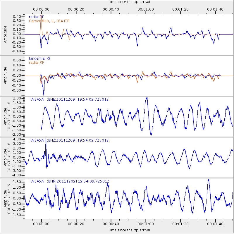
S45A Carrier Mills, IL, USA - Earthquake Result Viewer
*The percent match for this event was below the threshold and hence no stack was calculated.
| Earthquake location: |
Sea Of Okhotsk |
| Earthquake latitude/longitude: |
47.0/144.6 |
| Earthquake time(UTC): |
2011/12/09 (343) 19:42:57 GMT |
| Earthquake Depth: |
392 km |
| Earthquake Magnitude: |
5.7 MB, 5.7 MW, 5.8 MW |
| Earthquake Catalog/Contributor: |
WHDF/NEIC |
|
| Network: |
TA USArray Transportable Network (new EarthScope stations) |
| Station: |
S45A Carrier Mills, IL, USA |
| Lat/Lon: |
37.68 N/88.58 W |
| Elevation: |
122 m |
|
| Distance: |
83.2 deg |
| Az: |
39.735 deg |
| Baz: |
326.542 deg |
| Ray Param: |
$rayparam |
*The percent match for this event was below the threshold and hence was not used in the summary stack. |
|
| Radial Match: |
41.024326 % |
| Radial Bump: |
400 |
| Transverse Match: |
85.95727 % |
| Transverse Bump: |
400 |
| SOD ConfigId: |
432046 |
| Insert Time: |
2012-03-08 01:20:49.802 +0000 |
| GWidth: |
2.5 |
| Max Bumps: |
400 |
| Tol: |
0.001 |
|
Signal To Noise
| Channel | StoN | STA | LTA |
| TA:S45A: :BHZ:20111209T19:54:09.72501Z | 1.6498796 | 1.250009E-6 | 7.576365E-7 |
| TA:S45A: :BHN:20111209T19:54:09.72501Z | 0.41592774 | 3.4543987E-7 | 8.3052856E-7 |
| TA:S45A: :BHE:20111209T19:54:09.72501Z | 0.81493413 | 5.6629176E-7 | 6.9489266E-7 |
| Arrivals |
| Ps | |
| PpPs | |
| PsPs/PpSs | |


