You are here: Home > Network List > G - GEOSCOPE Stations List
> Station HYB Hyderabad, India > Earthquake Result Viewer
HYB Hyderabad, India - Earthquake Result Viewer
| Earthquake location: |
Philippine Islands Region |
| Earthquake latitude/longitude: |
7.7/127.6 |
| Earthquake time(UTC): |
1997/03/11 (070) 19:22:00 GMT |
| Earthquake Depth: |
10 km |
| Earthquake Magnitude: |
6.3 MB, 6.7 MS, 6.9 UNKNOWN, 6.8 MW |
| Earthquake Catalog/Contributor: |
WHDF/NEIC |
|
| Network: |
G GEOSCOPE |
| Station: |
HYB Hyderabad, India |
| Lat/Lon: |
17.42 N/78.55 E |
| Elevation: |
510 m |
|
| Distance: |
48.7 deg |
| Az: |
286.311 deg |
| Baz: |
94.982 deg |
| Ray Param: |
0.069154374 |
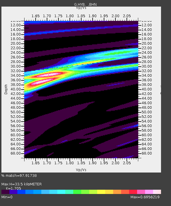
| Estimated Moho Depth: |
33.5 km |
| Estimated Crust Vp/Vs: |
1.71 |
| Assumed Crust Vp: |
6.459 km/s |
| Estimated Crust Vs: |
3.789 km/s |
| Estimated Crust Poisson's Ratio: |
0.24 |
|
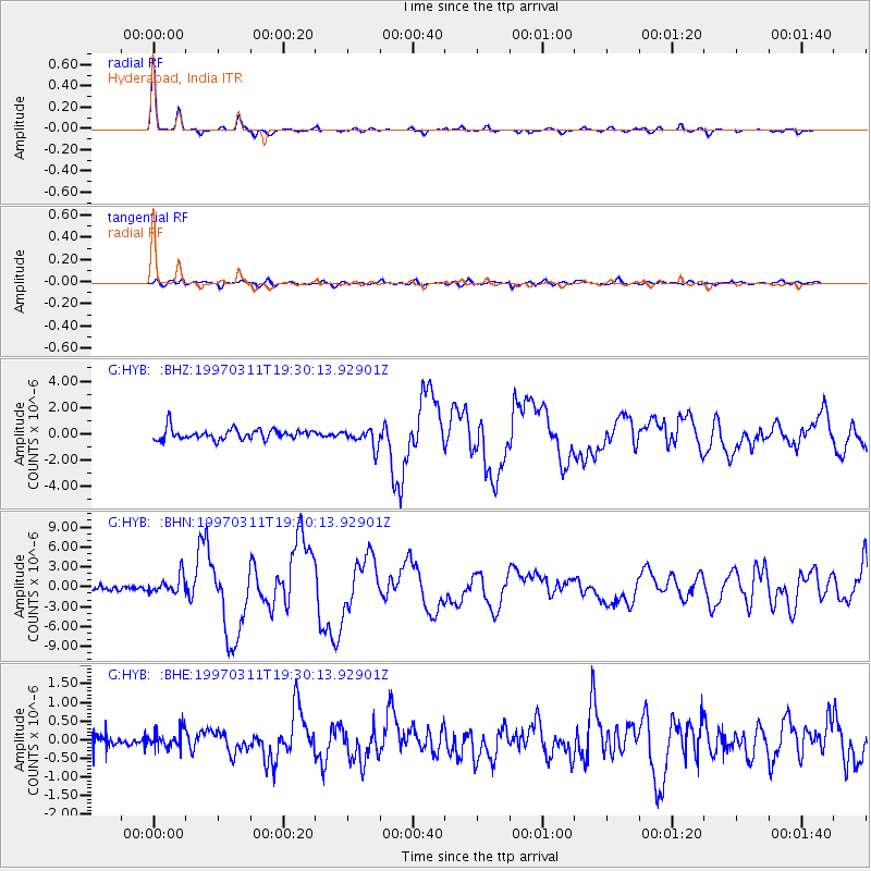
| Radial Match: |
97.91738 % |
| Radial Bump: |
243 |
| Transverse Match: |
77.24388 % |
| Transverse Bump: |
400 |
| SOD ConfigId: |
4480 |
| Insert Time: |
2010-02-26 22:57:40.994 +0000 |
| GWidth: |
2.5 |
| Max Bumps: |
400 |
| Tol: |
0.001 |
|
Signal To Noise
| Channel | StoN | STA | LTA |
| G:HYB: :BHN:19970311T19:30:13.92901Z | 1.9809283 | 1.401183E-6 | 7.0733654E-7 |
| G:HYB: :BHE:19970311T19:30:13.92901Z | 1.361101 | 2.3724155E-7 | 1.743012E-7 |
| G:HYB: :BHZ:19970311T19:30:13.92901Z | 1.7116188 | 6.922379E-7 | 4.0443464E-7 |
| Arrivals |
| Ps | 3.9 SECOND |
| PpPs | 13 SECOND |
| PsPs/PpSs | 17 SECOND |


