You are here: Home > Network List > G - GEOSCOPE Stations List
> Station HYB Hyderabad, India > Earthquake Result Viewer
HYB Hyderabad, India - Earthquake Result Viewer

| Earthquake location: |
Sunda Strait, Indonesia |
| Earthquake latitude/longitude: |
-6.6/105.5 |
| Earthquake time(UTC): |
1997/03/17 (076) 08:05:48 GMT |
| Earthquake Depth: |
33 km |
| Earthquake Magnitude: |
5.8 MB, 6.2 MS, 6.4 UNKNOWN, 6.3 MW |
| Earthquake Catalog/Contributor: |
WHDF/NEIC |
|
| Network: |
G GEOSCOPE |
| Station: |
HYB Hyderabad, India |
| Lat/Lon: |
17.42 N/78.55 E |
| Elevation: |
510 m |
|
| Distance: |
35.8 deg |
| Az: |
312.231 deg |
| Baz: |
129.604 deg |
| Ray Param: |
0.07698069 |
| Estimated Moho Depth: |
32.25 km |
| Estimated Crust Vp/Vs: |
1.73 |
| Assumed Crust Vp: |
6.459 km/s |
| Estimated Crust Vs: |
3.734 km/s |
| Estimated Crust Poisson's Ratio: |
0.25 |
|
| Radial Match: |
95.85945 % |
| Radial Bump: |
328 |
| Transverse Match: |
80.60967 % |
| Transverse Bump: |
400 |
| SOD ConfigId: |
4480 |
| Insert Time: |
2010-02-26 22:57:44.660 +0000 |
| GWidth: |
2.5 |
| Max Bumps: |
400 |
| Tol: |
0.001 |
|
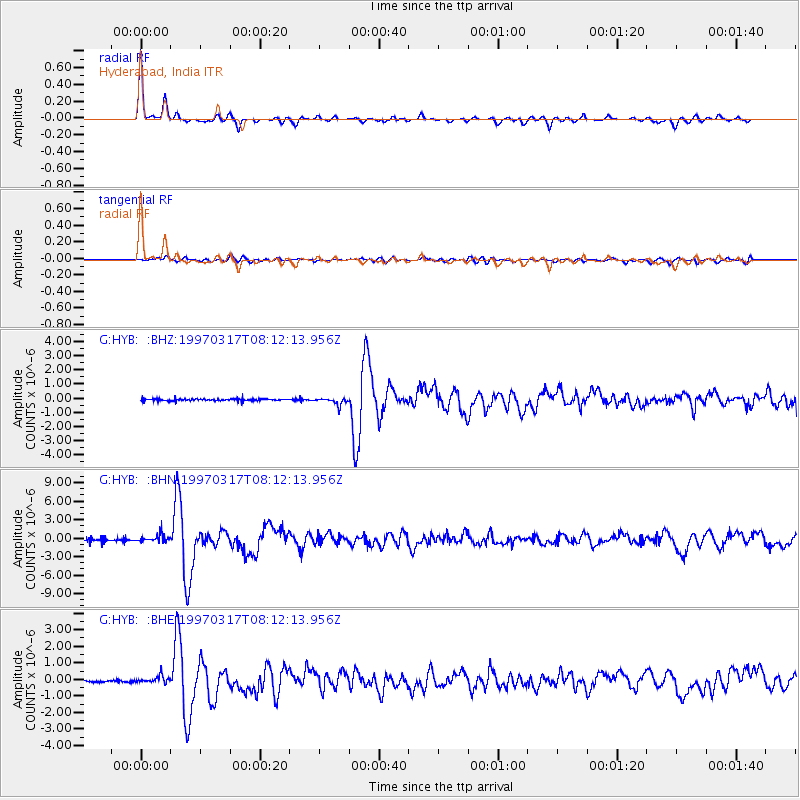
Signal To Noise
| Channel | StoN | STA | LTA |
| G:HYB: :BHN:19970317T08:12:13.956Z | 3.0341506 | 6.522816E-7 | 2.1497996E-7 |
| G:HYB: :BHE:19970317T08:12:13.956Z | 3.7347672 | 2.3008674E-7 | 6.160671E-8 |
| G:HYB: :BHZ:19970317T08:12:13.956Z | 3.4410155 | 2.5213345E-7 | 7.327298E-8 |
| Arrivals |
| Ps | 3.9 SECOND |
| PpPs | 13 SECOND |
| PsPs/PpSs | 17 SECOND |


