You are here: Home > Network List > TA - USArray Transportable Network (new EarthScope stations) Stations List
> Station G32A Webster, SD, USA > Earthquake Result Viewer
G32A Webster, SD, USA - Earthquake Result Viewer
*The percent match for this event was below the threshold and hence no stack was calculated.
| Earthquake location: |
Ryukyu Islands, Japan |
| Earthquake latitude/longitude: |
28.1/129.4 |
| Earthquake time(UTC): |
2011/12/11 (345) 01:22:45 GMT |
| Earthquake Depth: |
38 km |
| Earthquake Magnitude: |
5.7 MB, 5.3 MW, 5.4 MW |
| Earthquake Catalog/Contributor: |
WHDF/NEIC |
|
| Network: |
TA USArray Transportable Network (new EarthScope stations) |
| Station: |
G32A Webster, SD, USA |
| Lat/Lon: |
45.26 N/97.50 W |
| Elevation: |
566 m |
|
| Distance: |
95.4 deg |
| Az: |
31.183 deg |
| Baz: |
319.641 deg |
| Ray Param: |
$rayparam |
*The percent match for this event was below the threshold and hence was not used in the summary stack. |
|
| Radial Match: |
54.939045 % |
| Radial Bump: |
337 |
| Transverse Match: |
66.71516 % |
| Transverse Bump: |
400 |
| SOD ConfigId: |
434841 |
| Insert Time: |
2012-03-10 05:23:10.394 +0000 |
| GWidth: |
2.5 |
| Max Bumps: |
400 |
| Tol: |
0.001 |
|
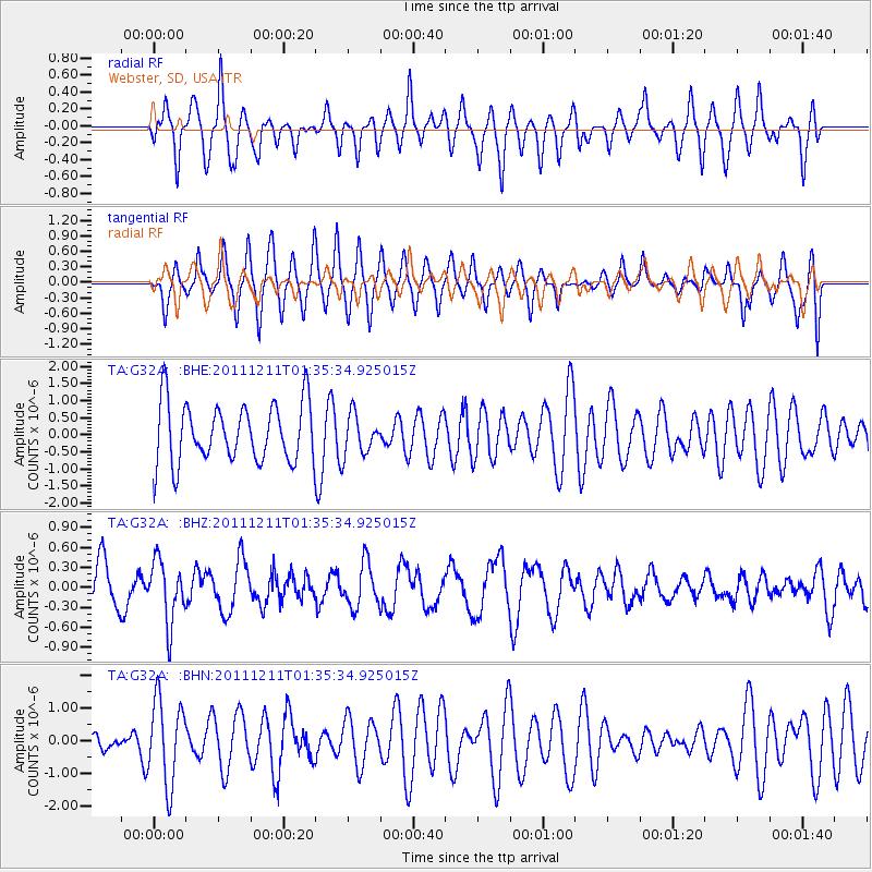
Signal To Noise
| Channel | StoN | STA | LTA |
| TA:G32A: :BHZ:20111211T01:35:34.925015Z | 1.9182209 | 4.6222337E-7 | 2.4096462E-7 |
| TA:G32A: :BHN:20111211T01:35:34.925015Z | 2.536784 | 1.2901376E-6 | 5.085721E-7 |
| TA:G32A: :BHE:20111211T01:35:34.925015Z | 0.67138976 | 5.815508E-7 | 8.6618957E-7 |
| Arrivals |
| Ps | |
| PpPs | |
| PsPs/PpSs | |


