You are here: Home > Network List > G - GEOSCOPE Stations List
> Station HYB Hyderabad, India > Earthquake Result Viewer
HYB Hyderabad, India - Earthquake Result Viewer
| Earthquake location: |
Halmahera, Indonesia |
| Earthquake latitude/longitude: |
-1.4/127.5 |
| Earthquake time(UTC): |
1995/02/13 (044) 08:41:14 GMT |
| Earthquake Depth: |
25 km |
| Earthquake Magnitude: |
5.7 MB, 5.5 MS, 5.8 UNKNOWN |
| Earthquake Catalog/Contributor: |
WHDF/NEIC |
|
| Network: |
G GEOSCOPE |
| Station: |
HYB Hyderabad, India |
| Lat/Lon: |
17.42 N/78.55 E |
| Elevation: |
510 m |
|
| Distance: |
51.7 deg |
| Az: |
293.446 deg |
| Baz: |
106.121 deg |
| Ray Param: |
0.06720979 |
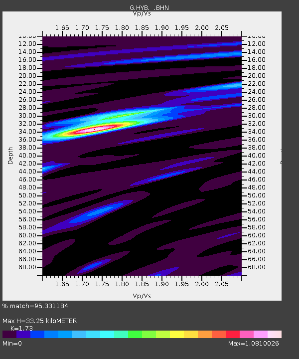
| Estimated Moho Depth: |
33.25 km |
| Estimated Crust Vp/Vs: |
1.73 |
| Assumed Crust Vp: |
6.459 km/s |
| Estimated Crust Vs: |
3.734 km/s |
| Estimated Crust Poisson's Ratio: |
0.25 |
|
| Radial Match: |
95.331184 % |
| Radial Bump: |
300 |
| Transverse Match: |
77.799904 % |
| Transverse Bump: |
400 |
| SOD ConfigId: |
4480 |
| Insert Time: |
2010-02-26 22:57:47.017 +0000 |
| GWidth: |
2.5 |
| Max Bumps: |
400 |
| Tol: |
0.001 |
|
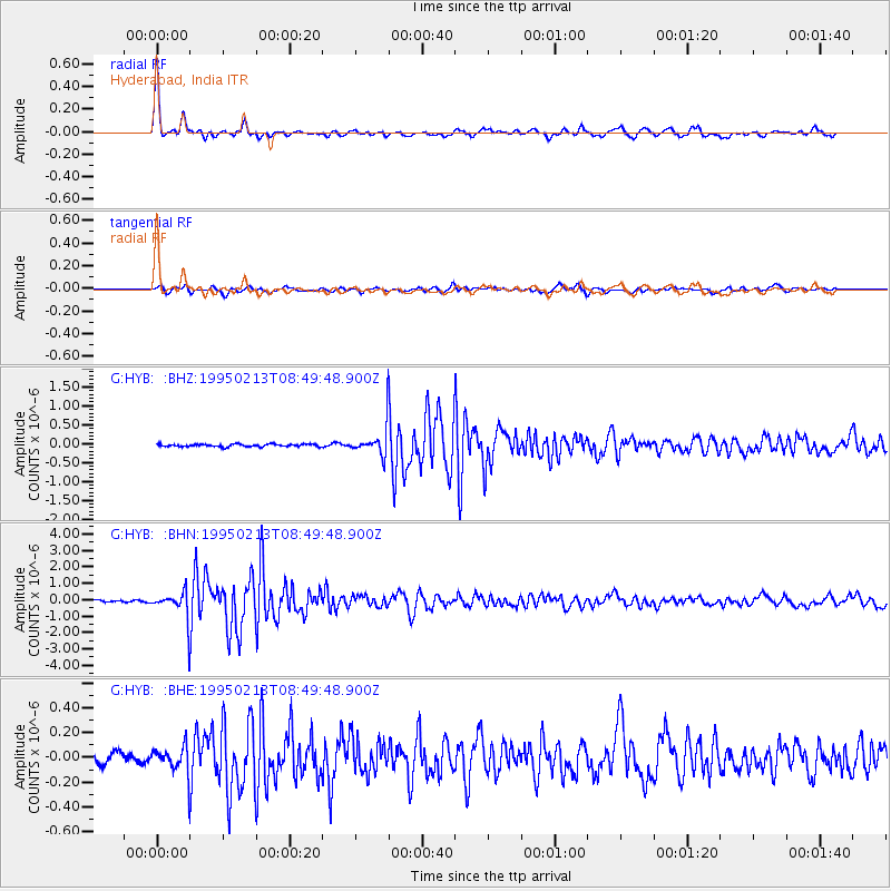
Signal To Noise
| Channel | StoN | STA | LTA |
| G:HYB: :BHN:19950213T08:49:48.900Z | 12.961481 | 7.9616507E-7 | 6.1425474E-8 |
| G:HYB: :BHE:19950213T08:49:48.900Z | 1.5671602 | 1.0917545E-7 | 6.9664516E-8 |
| G:HYB: :BHZ:19950213T08:49:48.900Z | 10.781603 | 3.6872189E-7 | 3.419917E-8 |
| Arrivals |
| Ps | 4.0 SECOND |
| PpPs | 13 SECOND |
| PsPs/PpSs | 17 SECOND |


