You are here: Home > Network List > GT - Global Telemetered Seismograph Network (USAF/USGS) Stations List
> Station LPAZ La Paz , Bolivia > Earthquake Result Viewer
LPAZ La Paz , Bolivia - Earthquake Result Viewer
| Earthquake location: |
Guerrero, Mexico |
| Earthquake latitude/longitude: |
17.8/-100.0 |
| Earthquake time(UTC): |
2011/12/11 (345) 01:47:25 GMT |
| Earthquake Depth: |
54 km |
| Earthquake Magnitude: |
6.2 MB, 6.5 MW, 6.5 MW |
| Earthquake Catalog/Contributor: |
WHDF/NEIC |
|
| Network: |
GT Global Telemetered Seismograph Network (USAF/USGS) |
| Station: |
LPAZ La Paz , Bolivia |
| Lat/Lon: |
16.17 S/68.08 W |
| Elevation: |
4817 m |
|
| Distance: |
46.1 deg |
| Az: |
135.258 deg |
| Baz: |
315.754 deg |
| Ray Param: |
0.070683025 |
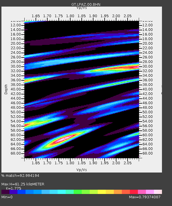
| Estimated Moho Depth: |
61.25 km |
| Estimated Crust Vp/Vs: |
1.77 |
| Assumed Crust Vp: |
6.454 km/s |
| Estimated Crust Vs: |
3.636 km/s |
| Estimated Crust Poisson's Ratio: |
0.27 |
|
| Radial Match: |
92.994194 % |
| Radial Bump: |
400 |
| Transverse Match: |
78.26028 % |
| Transverse Bump: |
400 |
| SOD ConfigId: |
434841 |
| Insert Time: |
2012-03-10 05:36:50.075 +0000 |
| GWidth: |
2.5 |
| Max Bumps: |
400 |
| Tol: |
0.001 |
|

Signal To Noise
| Channel | StoN | STA | LTA |
| GT:LPAZ:00:BHZ:20111211T01:55:14.875006Z | 15.086779 | 1.4234652E-6 | 9.4351826E-8 |
| GT:LPAZ:00:BHN:20111211T01:55:14.875006Z | 5.102222 | 7.2924223E-7 | 1.429264E-7 |
| GT:LPAZ:00:BHE:20111211T01:55:14.875006Z | 4.7413793 | 4.847989E-7 | 1.0224849E-7 |
| Arrivals |
| Ps | 7.8 SECOND |
| PpPs | 25 SECOND |
| PsPs/PpSs | 33 SECOND |


