You are here: Home > Network List > LD - Lamont-Doherty Cooperative Seismographic Network Stations List
> Station WCNY West Carthage, New York > Earthquake Result Viewer
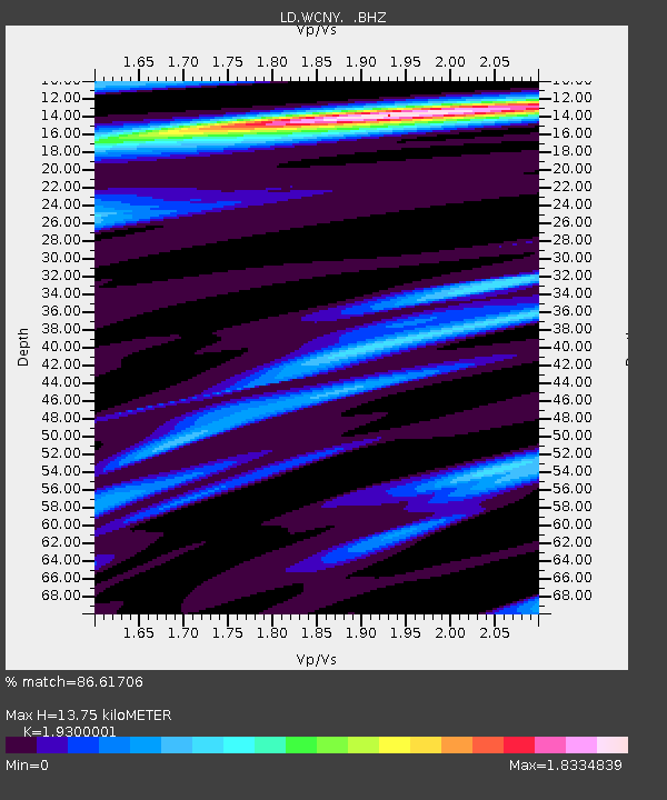
WCNY West Carthage, New York - Earthquake Result Viewer
| Earthquake location: |
Guerrero, Mexico |
| Earthquake latitude/longitude: |
17.8/-100.0 |
| Earthquake time(UTC): |
2011/12/11 (345) 01:47:25 GMT |
| Earthquake Depth: |
54 km |
| Earthquake Magnitude: |
6.2 MB, 6.5 MW, 6.5 MW |
| Earthquake Catalog/Contributor: |
WHDF/NEIC |
|
| Network: |
LD Lamont-Doherty Cooperative Seismographic Network |
| Station: |
WCNY West Carthage, New York |
| Lat/Lon: |
43.98 N/75.65 W |
| Elevation: |
245 m |
|
| Distance: |
33.1 deg |
| Az: |
32.934 deg |
| Baz: |
225.835 deg |
| Ray Param: |
0.07822404 |
| Estimated Moho Depth: |
13.75 km |
| Estimated Crust Vp/Vs: |
1.93 |
| Assumed Crust Vp: |
6.419 km/s |
| Estimated Crust Vs: |
3.326 km/s |
| Estimated Crust Poisson's Ratio: |
0.32 |
|
| Radial Match: |
86.61706 % |
| Radial Bump: |
318 |
| Transverse Match: |
47.929783 % |
| Transverse Bump: |
400 |
| SOD ConfigId: |
434841 |
| Insert Time: |
2012-03-10 05:38:54.973 +0000 |
| GWidth: |
2.5 |
| Max Bumps: |
400 |
| Tol: |
0.001 |
|

Signal To Noise
| Channel | StoN | STA | LTA |
| LD:WCNY: :BHZ:20111211T01:53:26.669989Z | 3.1325276 | 1.0199304E-6 | 3.2559345E-7 |
| LD:WCNY: :BHN:20111211T01:53:26.669989Z | 1.6853876 | 3.7561233E-7 | 2.2286407E-7 |
| LD:WCNY: :BHE:20111211T01:53:26.669989Z | 1.2157282 | 3.1316884E-7 | 2.5759775E-7 |
| Arrivals |
| Ps | 2.1 SECOND |
| PpPs | 5.8 SECOND |
| PsPs/PpSs | 8.0 SECOND |


