You are here: Home > Network List > LX - University of LISbon SEISmic Network Stations List
> Station MORF Marmelete, Algarve, Portugal > Earthquake Result Viewer
MORF Marmelete, Algarve, Portugal - Earthquake Result Viewer
| Earthquake location: |
Guerrero, Mexico |
| Earthquake latitude/longitude: |
17.8/-100.0 |
| Earthquake time(UTC): |
2011/12/11 (345) 01:47:25 GMT |
| Earthquake Depth: |
54 km |
| Earthquake Magnitude: |
6.2 MB, 6.5 MW, 6.5 MW |
| Earthquake Catalog/Contributor: |
WHDF/NEIC |
|
| Network: |
LX University of LISbon SEISmic Network |
| Station: |
MORF Marmelete, Algarve, Portugal |
| Lat/Lon: |
37.30 N/8.65 W |
| Elevation: |
560 m |
|
| Distance: |
80.4 deg |
| Az: |
53.945 deg |
| Baz: |
285.048 deg |
| Ray Param: |
0.04818989 |
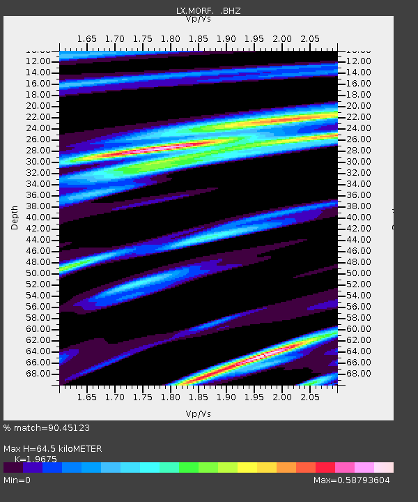
| Estimated Moho Depth: |
64.5 km |
| Estimated Crust Vp/Vs: |
1.97 |
| Assumed Crust Vp: |
6.048 km/s |
| Estimated Crust Vs: |
3.074 km/s |
| Estimated Crust Poisson's Ratio: |
0.33 |
|
| Radial Match: |
90.45123 % |
| Radial Bump: |
368 |
| Transverse Match: |
84.31129 % |
| Transverse Bump: |
400 |
| SOD ConfigId: |
434841 |
| Insert Time: |
2012-03-10 05:39:27.118 +0000 |
| GWidth: |
2.5 |
| Max Bumps: |
400 |
| Tol: |
0.001 |
|

Signal To Noise
| Channel | StoN | STA | LTA |
| LX:MORF: :BHZ:20111211T01:59:00.650Z | 16.014519 | 3.9098773E-6 | 2.4414578E-7 |
| LX:MORF: :BHN:20111211T01:59:00.689978Z | 3.713934 | 9.401006E-7 | 2.5312798E-7 |
| LX:MORF: :BHE:20111211T01:59:00.689978Z | 4.848468 | 1.5143015E-6 | 3.123258E-7 |
| Arrivals |
| Ps | 11 SECOND |
| PpPs | 31 SECOND |
| PsPs/PpSs | 42 SECOND |


