You are here: Home > Network List > TA - USArray Transportable Network (new EarthScope stations) Stations List
> Station J05D Fort Rock, OR, USA > Earthquake Result Viewer
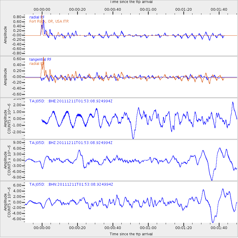
J05D Fort Rock, OR, USA - Earthquake Result Viewer

| Earthquake location: |
Guerrero, Mexico |
| Earthquake latitude/longitude: |
17.8/-100.0 |
| Earthquake time(UTC): |
2011/12/11 (345) 01:47:25 GMT |
| Earthquake Depth: |
54 km |
| Earthquake Magnitude: |
6.2 MB, 6.5 MW, 6.5 MW |
| Earthquake Catalog/Contributor: |
WHDF/NEIC |
|
| Network: |
TA USArray Transportable Network (new EarthScope stations) |
| Station: |
J05D Fort Rock, OR, USA |
| Lat/Lon: |
43.28 N/121.23 W |
| Elevation: |
1541 m |
|
| Distance: |
31.1 deg |
| Az: |
329.146 deg |
| Baz: |
138.015 deg |
| Ray Param: |
0.07908559 |
| Estimated Moho Depth: |
12.75 km |
| Estimated Crust Vp/Vs: |
2.09 |
| Assumed Crust Vp: |
6.597 km/s |
| Estimated Crust Vs: |
3.164 km/s |
| Estimated Crust Poisson's Ratio: |
0.35 |
|
| Radial Match: |
89.5342 % |
| Radial Bump: |
400 |
| Transverse Match: |
59.858578 % |
| Transverse Bump: |
400 |
| SOD ConfigId: |
434841 |
| Insert Time: |
2012-03-10 05:42:59.245 +0000 |
| GWidth: |
2.5 |
| Max Bumps: |
400 |
| Tol: |
0.001 |
|
Signal To Noise
| Channel | StoN | STA | LTA |
| TA:J05D: :BHZ:20111211T01:53:08.924994Z | 3.6928835 | 2.1340893E-6 | 5.778924E-7 |
| TA:J05D: :BHN:20111211T01:53:08.924994Z | 2.2429187 | 1.1890742E-6 | 5.301459E-7 |
| TA:J05D: :BHE:20111211T01:53:08.924994Z | 1.3859627 | 9.292845E-7 | 6.7049746E-7 |
| Arrivals |
| Ps | 2.3 SECOND |
| PpPs | 5.5 SECOND |
| PsPs/PpSs | 7.8 SECOND |


