You are here: Home > Network List > TA - USArray Transportable Network (new EarthScope stations) Stations List
> Station I03D Drain, OR, USA > Earthquake Result Viewer
I03D Drain, OR, USA - Earthquake Result Viewer
| Earthquake location: |
Guerrero, Mexico |
| Earthquake latitude/longitude: |
17.8/-100.0 |
| Earthquake time(UTC): |
2011/12/11 (345) 01:47:25 GMT |
| Earthquake Depth: |
54 km |
| Earthquake Magnitude: |
6.2 MB, 6.5 MW, 6.5 MW |
| Earthquake Catalog/Contributor: |
WHDF/NEIC |
|
| Network: |
TA USArray Transportable Network (new EarthScope stations) |
| Station: |
I03D Drain, OR, USA |
| Lat/Lon: |
43.70 N/123.35 W |
| Elevation: |
140 m |
|
| Distance: |
32.5 deg |
| Az: |
327.56 deg |
| Baz: |
135.217 deg |
| Ray Param: |
0.078527674 |
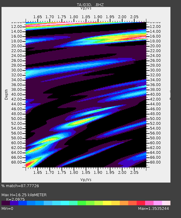
| Estimated Moho Depth: |
16.25 km |
| Estimated Crust Vp/Vs: |
2.10 |
| Assumed Crust Vp: |
6.522 km/s |
| Estimated Crust Vs: |
3.109 km/s |
| Estimated Crust Poisson's Ratio: |
0.35 |
|
| Radial Match: |
87.77726 % |
| Radial Bump: |
400 |
| Transverse Match: |
61.570663 % |
| Transverse Bump: |
400 |
| SOD ConfigId: |
434841 |
| Insert Time: |
2012-03-10 05:43:33.689 +0000 |
| GWidth: |
2.5 |
| Max Bumps: |
400 |
| Tol: |
0.001 |
|

Signal To Noise
| Channel | StoN | STA | LTA |
| TA:I03D: :BHZ:20111211T01:53:20.799994Z | 8.265361 | 2.9359494E-6 | 3.5521126E-7 |
| TA:I03D: :BHN:20111211T01:53:20.799994Z | 4.8730683 | 1.4900274E-6 | 3.0576783E-7 |
| TA:I03D: :BHE:20111211T01:53:20.799994Z | 2.8238266 | 9.799168E-7 | 3.4701733E-7 |
| Arrivals |
| Ps | 2.9 SECOND |
| PpPs | 7.2 SECOND |
| PsPs/PpSs | 10 SECOND |


