You are here: Home > Network List > TA - USArray Transportable Network (new EarthScope stations) Stations List
> Station L04D Klamath Falls, OR, USA > Earthquake Result Viewer
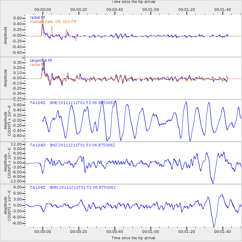
L04D Klamath Falls, OR, USA - Earthquake Result Viewer
*The percent match for this event was below the threshold and hence no stack was calculated.
| Earthquake location: |
Guerrero, Mexico |
| Earthquake latitude/longitude: |
17.8/-100.0 |
| Earthquake time(UTC): |
2011/12/11 (345) 01:47:25 GMT |
| Earthquake Depth: |
54 km |
| Earthquake Magnitude: |
6.2 MB, 6.5 MW, 6.5 MW |
| Earthquake Catalog/Contributor: |
WHDF/NEIC |
|
| Network: |
TA USArray Transportable Network (new EarthScope stations) |
| Station: |
L04D Klamath Falls, OR, USA |
| Lat/Lon: |
42.22 N/122.30 W |
| Elevation: |
1437 m |
|
| Distance: |
30.9 deg |
| Az: |
326.61 deg |
| Baz: |
135.118 deg |
| Ray Param: |
$rayparam |
*The percent match for this event was below the threshold and hence was not used in the summary stack. |
|
| Radial Match: |
85.08758 % |
| Radial Bump: |
400 |
| Transverse Match: |
84.72159 % |
| Transverse Bump: |
400 |
| SOD ConfigId: |
434841 |
| Insert Time: |
2012-03-10 05:44:00.561 +0000 |
| GWidth: |
2.5 |
| Max Bumps: |
400 |
| Tol: |
0.001 |
|
Signal To Noise
| Channel | StoN | STA | LTA |
| TA:L04D: :BHZ:20111211T01:53:06.875006Z | 11.710147 | 3.102919E-6 | 2.6497696E-7 |
| TA:L04D: :BHN:20111211T01:53:06.875006Z | 3.5934558 | 1.479079E-6 | 4.116035E-7 |
| TA:L04D: :BHE:20111211T01:53:06.875006Z | 1.2139647 | 4.0633023E-7 | 3.347134E-7 |
| Arrivals |
| Ps | |
| PpPs | |
| PsPs/PpSs | |


