You are here: Home > Network List > TA - USArray Transportable Network (new EarthScope stations) Stations List
> Station A04D Lummi Island, WA, USA > Earthquake Result Viewer
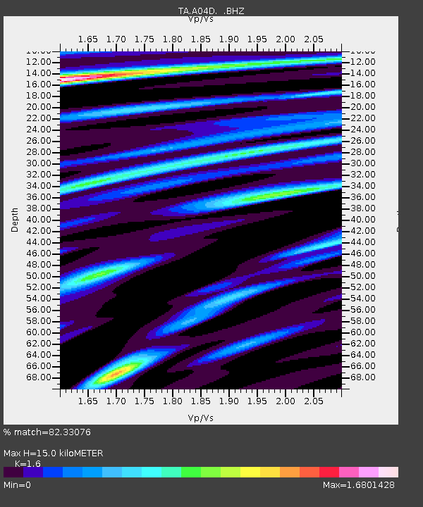
A04D Lummi Island, WA, USA - Earthquake Result Viewer
| Earthquake location: |
Guerrero, Mexico |
| Earthquake latitude/longitude: |
17.8/-100.0 |
| Earthquake time(UTC): |
2011/12/11 (345) 01:47:25 GMT |
| Earthquake Depth: |
54 km |
| Earthquake Magnitude: |
6.2 MB, 6.5 MW, 6.5 MW |
| Earthquake Catalog/Contributor: |
WHDF/NEIC |
|
| Network: |
TA USArray Transportable Network (new EarthScope stations) |
| Station: |
A04D Lummi Island, WA, USA |
| Lat/Lon: |
48.72 N/122.71 W |
| Elevation: |
13 m |
|
| Distance: |
35.9 deg |
| Az: |
334.118 deg |
| Baz: |
141.109 deg |
| Ray Param: |
0.07682572 |
| Estimated Moho Depth: |
15.0 km |
| Estimated Crust Vp/Vs: |
1.60 |
| Assumed Crust Vp: |
6.566 km/s |
| Estimated Crust Vs: |
4.104 km/s |
| Estimated Crust Poisson's Ratio: |
0.18 |
|
| Radial Match: |
82.33076 % |
| Radial Bump: |
400 |
| Transverse Match: |
57.878834 % |
| Transverse Bump: |
400 |
| SOD ConfigId: |
434841 |
| Insert Time: |
2012-03-10 05:45:03.350 +0000 |
| GWidth: |
2.5 |
| Max Bumps: |
400 |
| Tol: |
0.001 |
|

Signal To Noise
| Channel | StoN | STA | LTA |
| TA:A04D: :BHZ:20111211T01:53:50.574988Z | 5.45434 | 3.2563337E-6 | 5.97017E-7 |
| TA:A04D: :BHN:20111211T01:53:50.574988Z | 5.441184 | 1.6346136E-6 | 3.0041505E-7 |
| TA:A04D: :BHE:20111211T01:53:50.574988Z | 3.0041833 | 1.4837804E-6 | 4.9390474E-7 |
| Arrivals |
| Ps | 1.5 SECOND |
| PpPs | 5.4 SECOND |
| PsPs/PpSs | 6.9 SECOND |


