You are here: Home > Network List > TA - USArray Transportable Network (new EarthScope stations) Stations List
> Station C31A Landman Farms, Northwood, ND, USA > Earthquake Result Viewer
C31A Landman Farms, Northwood, ND, USA - Earthquake Result Viewer
| Earthquake location: |
Guerrero, Mexico |
| Earthquake latitude/longitude: |
17.8/-100.0 |
| Earthquake time(UTC): |
2011/12/11 (345) 01:47:25 GMT |
| Earthquake Depth: |
54 km |
| Earthquake Magnitude: |
6.2 MB, 6.5 MW, 6.5 MW |
| Earthquake Catalog/Contributor: |
WHDF/NEIC |
|
| Network: |
TA USArray Transportable Network (new EarthScope stations) |
| Station: |
C31A Landman Farms, Northwood, ND, USA |
| Lat/Lon: |
47.79 N/97.73 W |
| Elevation: |
384 m |
|
| Distance: |
29.9 deg |
| Az: |
3.014 deg |
| Baz: |
184.259 deg |
| Ray Param: |
0.07939461 |
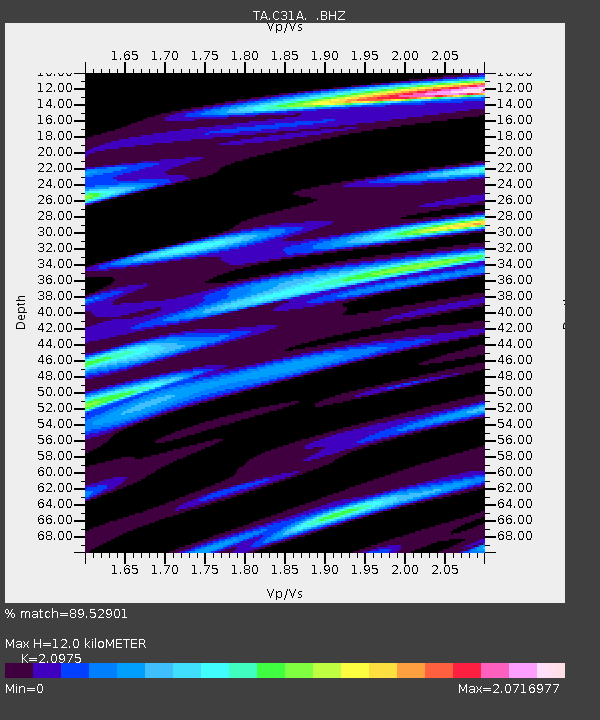
| Estimated Moho Depth: |
12.0 km |
| Estimated Crust Vp/Vs: |
2.10 |
| Assumed Crust Vp: |
6.498 km/s |
| Estimated Crust Vs: |
3.098 km/s |
| Estimated Crust Poisson's Ratio: |
0.35 |
|
| Radial Match: |
89.52901 % |
| Radial Bump: |
400 |
| Transverse Match: |
57.450657 % |
| Transverse Bump: |
400 |
| SOD ConfigId: |
434841 |
| Insert Time: |
2012-03-10 05:45:23.938 +0000 |
| GWidth: |
2.5 |
| Max Bumps: |
400 |
| Tol: |
0.001 |
|
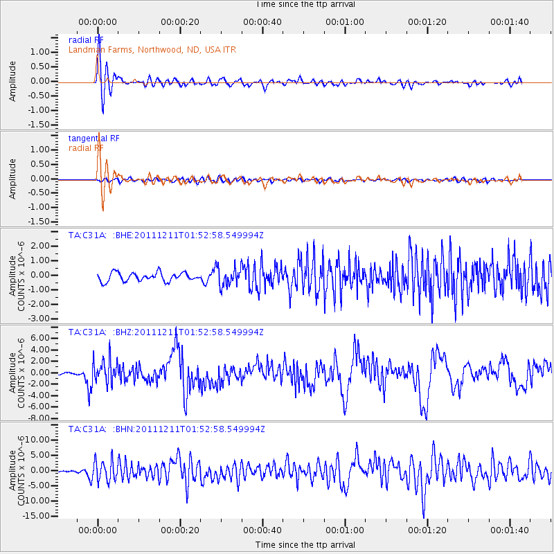
Signal To Noise
| Channel | StoN | STA | LTA |
| TA:C31A: :BHZ:20111211T01:52:58.549994Z | 6.3142476 | 2.0139298E-6 | 3.189501E-7 |
| TA:C31A: :BHN:20111211T01:52:58.549994Z | 7.7233906 | 3.3762512E-6 | 4.3714624E-7 |
| TA:C31A: :BHE:20111211T01:52:58.549994Z | 2.0566819 | 6.0274607E-7 | 2.9306722E-7 |
| Arrivals |
| Ps | 2.2 SECOND |
| PpPs | 5.3 SECOND |
| PsPs/PpSs | 7.5 SECOND |


