You are here: Home > Network List > TA - USArray Transportable Network (new EarthScope stations) Stations List
> Station E43A Lone Tree Farm, Eben Junction, MI, USA > Earthquake Result Viewer
E43A Lone Tree Farm, Eben Junction, MI, USA - Earthquake Result Viewer

| Earthquake location: |
Guerrero, Mexico |
| Earthquake latitude/longitude: |
17.8/-100.0 |
| Earthquake time(UTC): |
2011/12/11 (345) 01:47:25 GMT |
| Earthquake Depth: |
54 km |
| Earthquake Magnitude: |
6.2 MB, 6.5 MW, 6.5 MW |
| Earthquake Catalog/Contributor: |
WHDF/NEIC |
|
| Network: |
TA USArray Transportable Network (new EarthScope stations) |
| Station: |
E43A Lone Tree Farm, Eben Junction, MI, USA |
| Lat/Lon: |
46.38 N/87.00 W |
| Elevation: |
303 m |
|
| Distance: |
30.4 deg |
| Az: |
17.873 deg |
| Baz: |
204.975 deg |
| Ray Param: |
0.07926668 |
| Estimated Moho Depth: |
31.0 km |
| Estimated Crust Vp/Vs: |
1.97 |
| Assumed Crust Vp: |
6.472 km/s |
| Estimated Crust Vs: |
3.285 km/s |
| Estimated Crust Poisson's Ratio: |
0.33 |
|
| Radial Match: |
94.28471 % |
| Radial Bump: |
304 |
| Transverse Match: |
56.038948 % |
| Transverse Bump: |
400 |
| SOD ConfigId: |
434841 |
| Insert Time: |
2012-03-10 05:48:19.126 +0000 |
| GWidth: |
2.5 |
| Max Bumps: |
400 |
| Tol: |
0.001 |
|
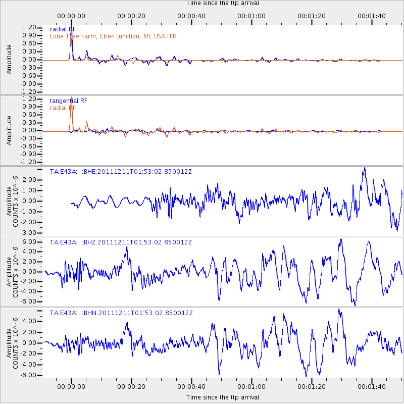
Signal To Noise
| Channel | StoN | STA | LTA |
| TA:E43A: :BHZ:20111211T01:53:02.850012Z | 4.436179 | 1.4742332E-6 | 3.3232047E-7 |
| TA:E43A: :BHN:20111211T01:53:02.850012Z | 3.1859865 | 9.1981445E-7 | 2.887063E-7 |
| TA:E43A: :BHE:20111211T01:53:02.850012Z | 2.1536996 | 6.557953E-7 | 3.0449712E-7 |
| Arrivals |
| Ps | 5.0 SECOND |
| PpPs | 13 SECOND |
| PsPs/PpSs | 18 SECOND |


