You are here: Home > Network List > UW - Pacific Northwest Regional Seismic Network Stations List
> Station UMAT Pilot Rock, OR, USA > Earthquake Result Viewer
UMAT Pilot Rock, OR, USA - Earthquake Result Viewer
| Earthquake location: |
Guerrero, Mexico |
| Earthquake latitude/longitude: |
17.8/-100.0 |
| Earthquake time(UTC): |
2011/12/11 (345) 01:47:25 GMT |
| Earthquake Depth: |
54 km |
| Earthquake Magnitude: |
6.2 MB, 6.5 MW, 6.5 MW |
| Earthquake Catalog/Contributor: |
WHDF/NEIC |
|
| Network: |
UW Pacific Northwest Regional Seismic Network |
| Station: |
UMAT Pilot Rock, OR, USA |
| Lat/Lon: |
45.29 N/118.96 W |
| Elevation: |
1318 m |
|
| Distance: |
31.6 deg |
| Az: |
334.013 deg |
| Baz: |
143.755 deg |
| Ray Param: |
0.07888042 |
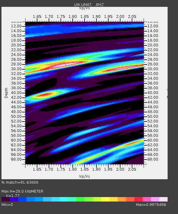
| Estimated Moho Depth: |
28.0 km |
| Estimated Crust Vp/Vs: |
1.77 |
| Assumed Crust Vp: |
6.571 km/s |
| Estimated Crust Vs: |
3.712 km/s |
| Estimated Crust Poisson's Ratio: |
0.27 |
|
| Radial Match: |
91.63808 % |
| Radial Bump: |
400 |
| Transverse Match: |
62.841312 % |
| Transverse Bump: |
400 |
| SOD ConfigId: |
434841 |
| Insert Time: |
2012-03-10 05:50:18.883 +0000 |
| GWidth: |
2.5 |
| Max Bumps: |
400 |
| Tol: |
0.001 |
|
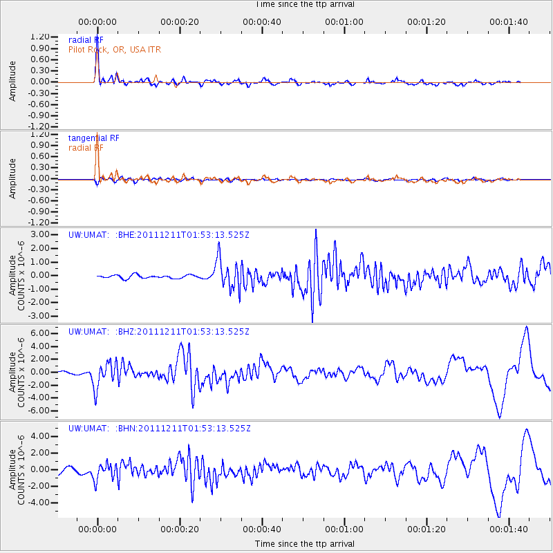
Signal To Noise
| Channel | StoN | STA | LTA |
| UW:UMAT: :BHZ:20111211T01:53:13.525Z | 5.8217645 | 2.0186887E-6 | 3.4674864E-7 |
| UW:UMAT: :BHN:20111211T01:53:13.525Z | 2.843891 | 9.814871E-7 | 3.451212E-7 |
| UW:UMAT: :BHE:20111211T01:53:13.525Z | 8.977055 | 1.1044874E-6 | 1.230345E-7 |
| Arrivals |
| Ps | 3.6 SECOND |
| PpPs | 11 SECOND |
| PsPs/PpSs | 14 SECOND |


