You are here: Home > Network List > UW - Pacific Northwest Regional Seismic Network Stations List
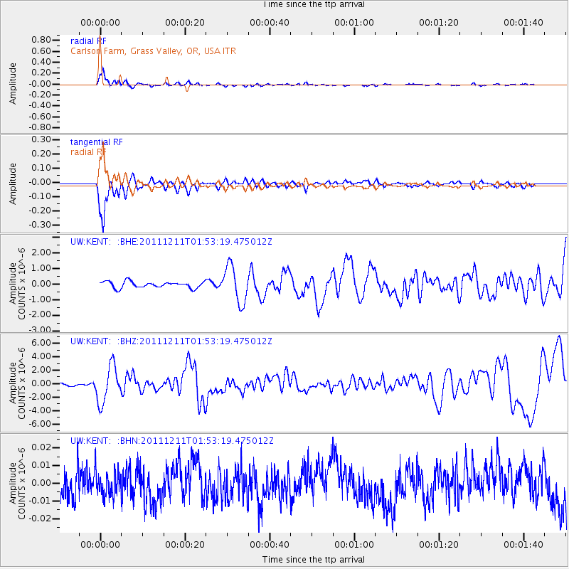
> Station KENT Carlson Farm, Grass Valley, OR, USA > Earthquake Result Viewer
KENT Carlson Farm, Grass Valley, OR, USA - Earthquake Result Viewer
| Earthquake location: |
Guerrero, Mexico |
| Earthquake latitude/longitude: |
17.8/-100.0 |
| Earthquake time(UTC): |
2011/12/11 (345) 01:47:25 GMT |
| Earthquake Depth: |
54 km |
| Earthquake Magnitude: |
6.2 MB, 6.5 MW, 6.5 MW |
| Earthquake Catalog/Contributor: |
WHDF/NEIC |
|
| Network: |
UW Pacific Northwest Regional Seismic Network |
| Station: |
KENT Carlson Farm, Grass Valley, OR, USA |
| Lat/Lon: |
45.24 N/120.64 W |
| Elevation: |
780 m |
|
| Distance: |
32.3 deg |
| Az: |
332.179 deg |
| Baz: |
141.013 deg |
| Ray Param: |
0.07859231 |
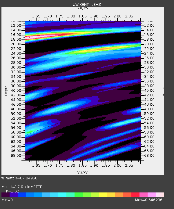
| Estimated Moho Depth: |
17.0 km |
| Estimated Crust Vp/Vs: |
1.62 |
| Assumed Crust Vp: |
6.597 km/s |
| Estimated Crust Vs: |
4.073 km/s |
| Estimated Crust Poisson's Ratio: |
0.19 |
|
| Radial Match: |
87.84958 % |
| Radial Bump: |
334 |
| Transverse Match: |
87.951065 % |
| Transverse Bump: |
340 |
| SOD ConfigId: |
434841 |
| Insert Time: |
2012-03-10 05:50:52.791 +0000 |
| GWidth: |
2.5 |
| Max Bumps: |
400 |
| Tol: |
0.001 |
|
Signal To Noise
| Channel | StoN | STA | LTA |
| UW:KENT: :BHZ:20111211T01:53:19.475012Z | 9.002179 | 2.806844E-6 | 3.1179604E-7 |
| UW:KENT: :BHN:20111211T01:53:19.475012Z | 0.60689473 | 5.818837E-9 | 9.587885E-9 |
| UW:KENT: :BHE:20111211T01:53:19.475012Z | 5.9726048 | 1.2047299E-6 | 2.0170931E-7 |
| Arrivals |
| Ps | 1.8 SECOND |
| PpPs | 6.2 SECOND |
| PsPs/PpSs | 7.9 SECOND |


