You are here: Home > Network List > TA - USArray Transportable Network (new EarthScope stations) Stations List
> Station TPFO Pinon Flats, CA, USA > Earthquake Result Viewer
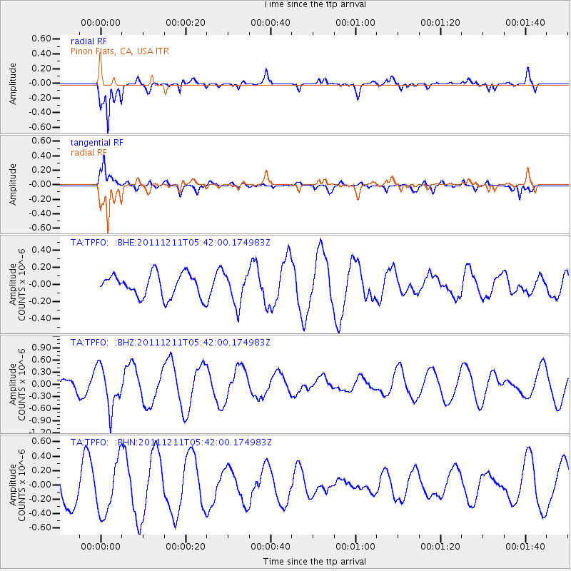
TPFO Pinon Flats, CA, USA - Earthquake Result Viewer
*The percent match for this event was below the threshold and hence no stack was calculated.
| Earthquake location: |
South Of Fiji Islands |
| Earthquake latitude/longitude: |
-24.1/178.6 |
| Earthquake time(UTC): |
2011/12/11 (345) 05:30:57 GMT |
| Earthquake Depth: |
556 km |
| Earthquake Magnitude: |
5.6 MW, 5.4 MB |
| Earthquake Catalog/Contributor: |
WHDF/NEIC |
|
| Network: |
TA USArray Transportable Network (new EarthScope stations) |
| Station: |
TPFO Pinon Flats, CA, USA |
| Lat/Lon: |
33.61 N/116.45 W |
| Elevation: |
1275 m |
|
| Distance: |
84.3 deg |
| Az: |
49.469 deg |
| Baz: |
236.342 deg |
| Ray Param: |
$rayparam |
*The percent match for this event was below the threshold and hence was not used in the summary stack. |
|
| Radial Match: |
78.49306 % |
| Radial Bump: |
365 |
| Transverse Match: |
70.437805 % |
| Transverse Bump: |
400 |
| SOD ConfigId: |
434841 |
| Insert Time: |
2012-03-10 06:09:40.306 +0000 |
| GWidth: |
2.5 |
| Max Bumps: |
400 |
| Tol: |
0.001 |
|
Signal To Noise
| Channel | StoN | STA | LTA |
| TA:TPFO: :BHZ:20111211T05:42:00.174983Z | 4.3571525 | 5.188221E-7 | 1.1907366E-7 |
| TA:TPFO: :BHN:20111211T05:42:00.174983Z | 1.3533903 | 3.7212155E-7 | 2.7495508E-7 |
| TA:TPFO: :BHE:20111211T05:42:00.174983Z | 1.3812871 | 1.8513819E-7 | 1.340331E-7 |
| Arrivals |
| Ps | |
| PpPs | |
| PsPs/PpSs | |


