You are here: Home > Network List > G - GEOSCOPE Stations List
> Station TAM Tamanrasset, Algeria > Earthquake Result Viewer
TAM Tamanrasset, Algeria - Earthquake Result Viewer
| Earthquake location: |
South Sandwich Islands Region |
| Earthquake latitude/longitude: |
-56.0/-28.2 |
| Earthquake time(UTC): |
2011/12/11 (345) 09:54:55 GMT |
| Earthquake Depth: |
116 km |
| Earthquake Magnitude: |
6.1 MB, 6.2 MW, 6.2 MW |
| Earthquake Catalog/Contributor: |
WHDF/NEIC |
|
| Network: |
G GEOSCOPE |
| Station: |
TAM Tamanrasset, Algeria |
| Lat/Lon: |
22.79 N/5.53 E |
| Elevation: |
1377 m |
|
| Distance: |
83.5 deg |
| Az: |
31.028 deg |
| Baz: |
198.283 deg |
| Ray Param: |
0.045854952 |
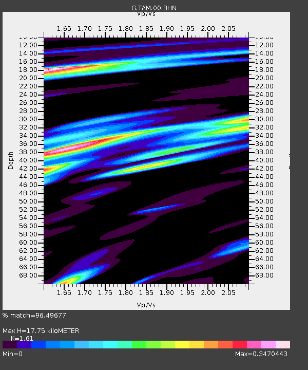
| Estimated Moho Depth: |
17.75 km |
| Estimated Crust Vp/Vs: |
1.61 |
| Assumed Crust Vp: |
6.61 km/s |
| Estimated Crust Vs: |
4.106 km/s |
| Estimated Crust Poisson's Ratio: |
0.19 |
|
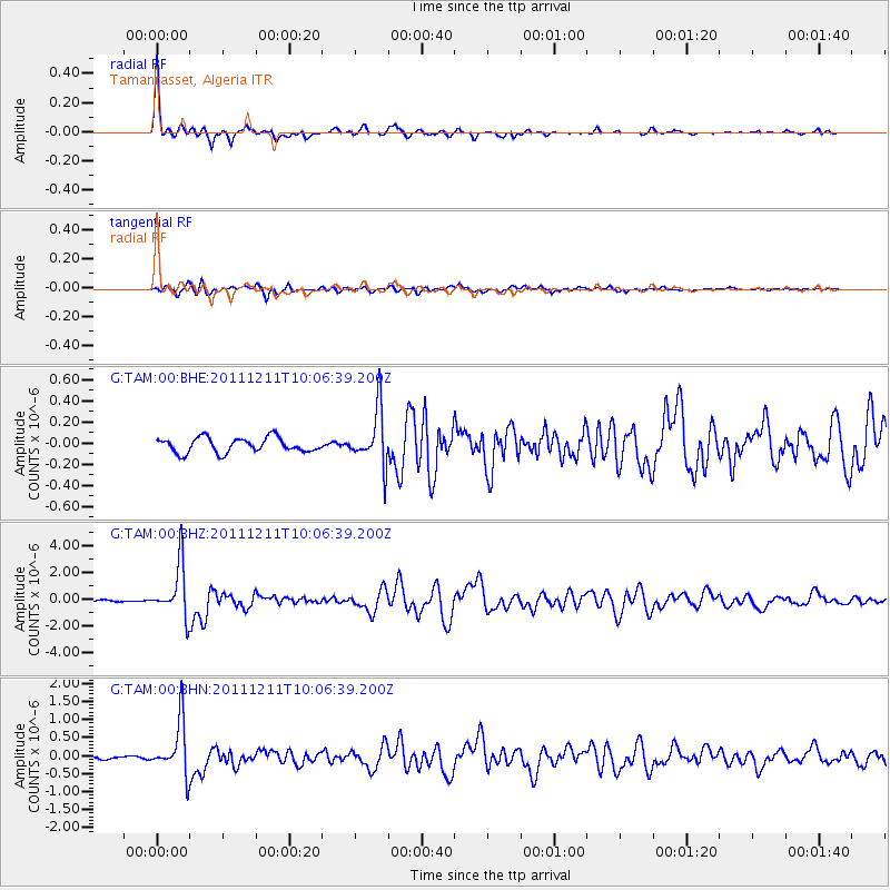
| Radial Match: |
96.49677 % |
| Radial Bump: |
269 |
| Transverse Match: |
83.97762 % |
| Transverse Bump: |
400 |
| SOD ConfigId: |
434841 |
| Insert Time: |
2012-03-10 06:19:33.398 +0000 |
| GWidth: |
2.5 |
| Max Bumps: |
400 |
| Tol: |
0.001 |
|
Signal To Noise
| Channel | StoN | STA | LTA |
| G:TAM:00:BHZ:20111211T10:06:39.200Z | 39.736996 | 1.9784322E-6 | 4.978817E-8 |
| G:TAM:00:BHN:20111211T10:06:39.200Z | 22.565325 | 7.4563326E-7 | 3.304332E-8 |
| G:TAM:00:BHE:20111211T10:06:39.200Z | 3.794726 | 2.657125E-7 | 7.002152E-8 |
| Arrivals |
| Ps | 1.7 SECOND |
| PpPs | 6.8 SECOND |
| PsPs/PpSs | 8.5 SECOND |


