You are here: Home > Network List > GT - Global Telemetered Seismograph Network (USAF/USGS) Stations List
> Station CPUP Villa Florida, Paraguay > Earthquake Result Viewer
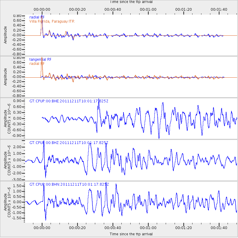
CPUP Villa Florida, Paraguay - Earthquake Result Viewer

| Earthquake location: |
South Sandwich Islands Region |
| Earthquake latitude/longitude: |
-56.0/-28.2 |
| Earthquake time(UTC): |
2011/12/11 (345) 09:54:55 GMT |
| Earthquake Depth: |
116 km |
| Earthquake Magnitude: |
6.1 MB, 6.2 MW, 6.2 MW |
| Earthquake Catalog/Contributor: |
WHDF/NEIC |
|
| Network: |
GT Global Telemetered Seismograph Network (USAF/USGS) |
| Station: |
CPUP Villa Florida, Paraguay |
| Lat/Lon: |
26.33 S/57.33 W |
| Elevation: |
105 m |
|
| Distance: |
36.4 deg |
| Az: |
312.514 deg |
| Baz: |
152.528 deg |
| Ray Param: |
0.0763331 |
| Estimated Moho Depth: |
37.75 km |
| Estimated Crust Vp/Vs: |
1.60 |
| Assumed Crust Vp: |
6.498 km/s |
| Estimated Crust Vs: |
4.055 km/s |
| Estimated Crust Poisson's Ratio: |
0.18 |
|
| Radial Match: |
93.54781 % |
| Radial Bump: |
340 |
| Transverse Match: |
75.3465 % |
| Transverse Bump: |
400 |
| SOD ConfigId: |
434841 |
| Insert Time: |
2012-03-10 06:20:15.883 +0000 |
| GWidth: |
2.5 |
| Max Bumps: |
400 |
| Tol: |
0.001 |
|
Signal To Noise
| Channel | StoN | STA | LTA |
| GT:CPUP:00:BHZ:20111211T10:01:17.825Z | 9.910278 | 1.1558452E-6 | 1.1663096E-7 |
| GT:CPUP:00:BHN:20111211T10:01:17.825Z | 6.9981594 | 6.859356E-7 | 9.801657E-8 |
| GT:CPUP:00:BHE:20111211T10:01:17.825Z | 4.6887045 | 4.0618812E-7 | 8.663121E-8 |
| Arrivals |
| Ps | 3.8 SECOND |
| PpPs | 14 SECOND |
| PsPs/PpSs | 18 SECOND |


