You are here: Home > Network List > NO - Norwegian Seismic Array Network Stations List
> Station SPB4 SPITSBERGEN ARRAY SITE B4, SVALBARD > Earthquake Result Viewer
SPB4 SPITSBERGEN ARRAY SITE B4, SVALBARD - Earthquake Result Viewer
| Earthquake location: |
Minahassa Peninsula, Sulawesi |
| Earthquake latitude/longitude: |
0.0/123.0 |
| Earthquake time(UTC): |
2011/12/13 (347) 07:52:11 GMT |
| Earthquake Depth: |
161 km |
| Earthquake Magnitude: |
6.3 MB, 6.0 MW, 6.0 MW |
| Earthquake Catalog/Contributor: |
WHDF/NEIC |
|
| Network: |
NO Norwegian Seismic Array Network |
| Station: |
SPB4 SPITSBERGEN ARRAY SITE B4, SVALBARD |
| Lat/Lon: |
78.18 N/16.35 E |
| Elevation: |
340 m |
|
| Distance: |
93.4 deg |
| Az: |
348.589 deg |
| Baz: |
73.649 deg |
| Ray Param: |
0.041184068 |
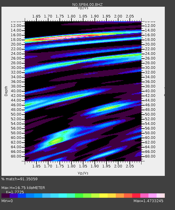
| Estimated Moho Depth: |
16.75 km |
| Estimated Crust Vp/Vs: |
1.77 |
| Assumed Crust Vp: |
6.545 km/s |
| Estimated Crust Vs: |
3.693 km/s |
| Estimated Crust Poisson's Ratio: |
0.27 |
|
| Radial Match: |
91.35059 % |
| Radial Bump: |
400 |
| Transverse Match: |
91.00939 % |
| Transverse Bump: |
400 |
| SOD ConfigId: |
434841 |
| Insert Time: |
2012-03-10 06:33:33.952 +0000 |
| GWidth: |
2.5 |
| Max Bumps: |
400 |
| Tol: |
0.001 |
|
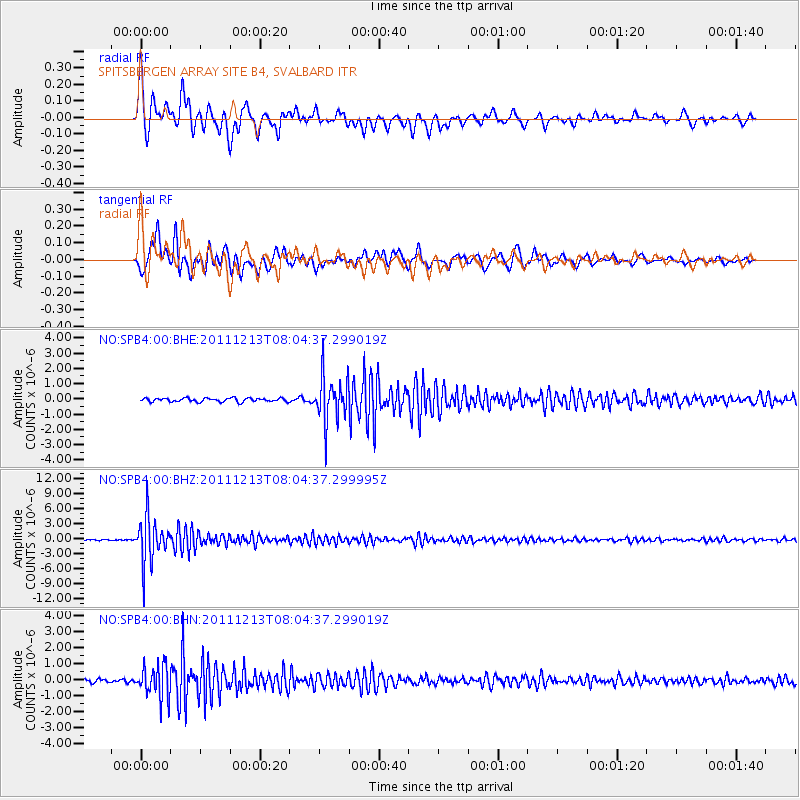
Signal To Noise
| Channel | StoN | STA | LTA |
| NO:SPB4:00:BHZ:20111213T08:04:37.299995Z | 38.053883 | 4.504252E-6 | 1.18365115E-7 |
| NO:SPB4:00:BHN:20111213T08:04:37.299019Z | 9.165802 | 1.0153376E-6 | 1.1077454E-7 |
| NO:SPB4:00:BHE:20111213T08:04:37.299019Z | 12.483887 | 1.5029344E-6 | 1.2038994E-7 |
| Arrivals |
| Ps | 2.0 SECOND |
| PpPs | 6.9 SECOND |
| PsPs/PpSs | 9.0 SECOND |


