You are here: Home > Network List > NO - Norwegian Seismic Array Network Stations List
> Station SPB1 SPITSBERGEN ARRAY SITE B1, SVALBARD > Earthquake Result Viewer
SPB1 SPITSBERGEN ARRAY SITE B1, SVALBARD - Earthquake Result Viewer
| Earthquake location: |
Minahassa Peninsula, Sulawesi |
| Earthquake latitude/longitude: |
0.0/123.0 |
| Earthquake time(UTC): |
2011/12/13 (347) 07:52:11 GMT |
| Earthquake Depth: |
161 km |
| Earthquake Magnitude: |
6.3 MB, 6.0 MW, 6.0 MW |
| Earthquake Catalog/Contributor: |
WHDF/NEIC |
|
| Network: |
NO Norwegian Seismic Array Network |
| Station: |
SPB1 SPITSBERGEN ARRAY SITE B1, SVALBARD |
| Lat/Lon: |
78.18 N/16.39 E |
| Elevation: |
301 m |
|
| Distance: |
93.3 deg |
| Az: |
348.587 deg |
| Baz: |
73.691 deg |
| Ray Param: |
0.04118576 |
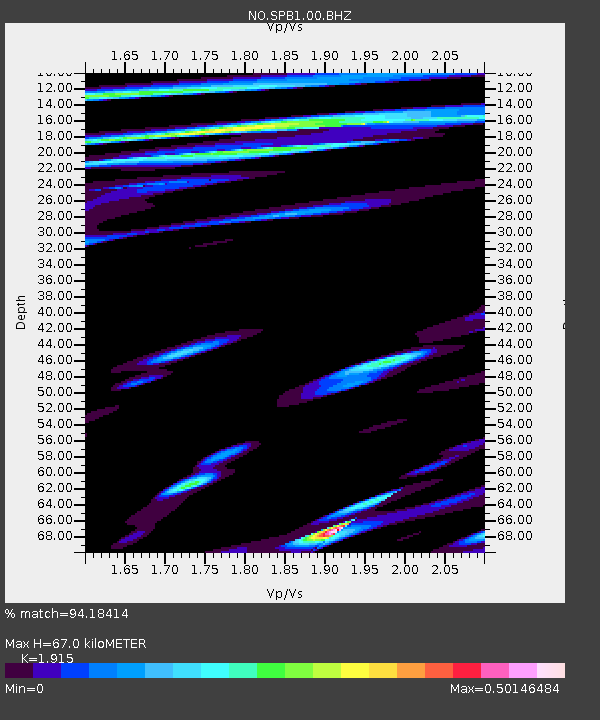
| Estimated Moho Depth: |
67.0 km |
| Estimated Crust Vp/Vs: |
1.91 |
| Assumed Crust Vp: |
6.545 km/s |
| Estimated Crust Vs: |
3.418 km/s |
| Estimated Crust Poisson's Ratio: |
0.31 |
|
| Radial Match: |
94.18414 % |
| Radial Bump: |
400 |
| Transverse Match: |
90.91977 % |
| Transverse Bump: |
400 |
| SOD ConfigId: |
434841 |
| Insert Time: |
2012-03-10 06:34:03.663 +0000 |
| GWidth: |
2.5 |
| Max Bumps: |
400 |
| Tol: |
0.001 |
|
Signal To Noise
| Channel | StoN | STA | LTA |
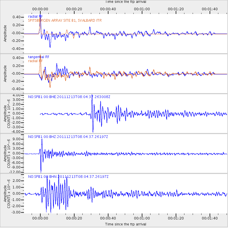
| NO:SPB1:00:BHZ:20111213T08:04:37.26197Z | 31.546179 | 3.8135765E-6 | 1.208887E-7 |
| NO:SPB1:00:BHN:20111213T08:04:37.26197Z | 9.391818 | 1.0818366E-6 | 1.1518926E-7 |
| NO:SPB1:00:BHE:20111213T08:04:37.263008Z | 14.326253 | 1.5353073E-6 | 1.0716741E-7 |
| Arrivals |
| Ps | 9.6 SECOND |
| PpPs | 29 SECOND |
| PsPs/PpSs | 39 SECOND |


