You are here: Home > Network List > AK - Alaska Regional Network Stations List
> Station BRLK Bradley Lake > Earthquake Result Viewer
BRLK Bradley Lake - Earthquake Result Viewer
| Earthquake location: |
Eastern New Guinea Reg., P.N.G. |
| Earthquake latitude/longitude: |
-7.6/146.8 |
| Earthquake time(UTC): |
2011/12/14 (348) 05:04:59 GMT |
| Earthquake Depth: |
141 km |
| Earthquake Magnitude: |
6.6 MB, 7.1 MW, 7.1 MW |
| Earthquake Catalog/Contributor: |
WHDF/NEIC |
|
| Network: |
AK Alaska Regional Network |
| Station: |
BRLK Bradley Lake |
| Lat/Lon: |
59.75 N/150.91 W |
| Elevation: |
409 m |
|
| Distance: |
83.1 deg |
| Az: |
26.841 deg |
| Baz: |
242.15 deg |
| Ray Param: |
0.046123378 |
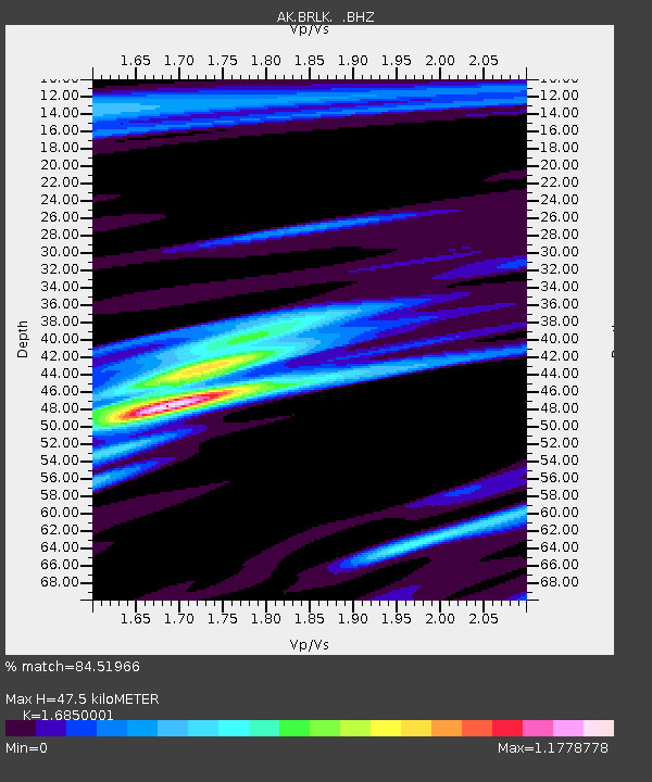
| Estimated Moho Depth: |
47.5 km |
| Estimated Crust Vp/Vs: |
1.69 |
| Assumed Crust Vp: |
6.24 km/s |
| Estimated Crust Vs: |
3.703 km/s |
| Estimated Crust Poisson's Ratio: |
0.23 |
|
| Radial Match: |
84.51966 % |
| Radial Bump: |
400 |
| Transverse Match: |
75.520584 % |
| Transverse Bump: |
400 |
| SOD ConfigId: |
434841 |
| Insert Time: |
2012-03-10 06:41:37.505 +0000 |
| GWidth: |
2.5 |
| Max Bumps: |
400 |
| Tol: |
0.001 |
|

Signal To Noise
| Channel | StoN | STA | LTA |
| AK:BRLK: :BHZ:20111214T05:16:37.947979Z | 15.402308 | 5.104228E-6 | 3.3139372E-7 |
| AK:BRLK: :BHN:20111214T05:16:37.947979Z | 2.901462 | 1.0760098E-6 | 3.708509E-7 |
| AK:BRLK: :BHE:20111214T05:16:37.947979Z | 5.3039403 | 2.2726854E-6 | 4.2849004E-7 |
| Arrivals |
| Ps | 5.3 SECOND |
| PpPs | 20 SECOND |
| PsPs/PpSs | 25 SECOND |


