You are here: Home > Network List > TA - USArray Transportable Network (new EarthScope stations) Stations List
> Station H17A Grant Village (NPS), Yellowstone Nt. Park, WY, USA > Earthquake Result Viewer
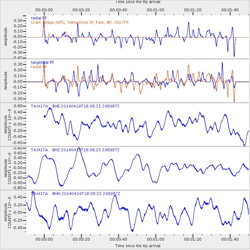
H17A Grant Village (NPS), Yellowstone Nt. Park, WY, USA - Earthquake Result Viewer
*The percent match for this event was below the threshold and hence no stack was calculated.
| Earthquake location: |
Solomon Islands |
| Earthquake latitude/longitude: |
-7.2/154.9 |
| Earthquake time(UTC): |
2014/04/19 (109) 17:55:22 GMT |
| Earthquake Depth: |
41 km |
| Earthquake Magnitude: |
5.3 mb |
| Earthquake Catalog/Contributor: |
ISC/ISC |
|
| Network: |
TA USArray Transportable Network (new EarthScope stations) |
| Station: |
H17A Grant Village (NPS), Yellowstone Nt. Park, WY, USA |
| Lat/Lon: |
44.40 N/110.58 W |
| Elevation: |
2400 m |
|
| Distance: |
98.2 deg |
| Az: |
46.22 deg |
| Baz: |
267.999 deg |
| Ray Param: |
$rayparam |
*The percent match for this event was below the threshold and hence was not used in the summary stack. |
|
| Radial Match: |
51.544453 % |
| Radial Bump: |
400 |
| Transverse Match: |
63.254917 % |
| Transverse Bump: |
400 |
| SOD ConfigId: |
3390531 |
| Insert Time: |
2019-04-11 12:40:38.477 +0000 |
| GWidth: |
2.5 |
| Max Bumps: |
400 |
| Tol: |
0.001 |
|
Signal To Noise
| Channel | StoN | STA | LTA |
| TA:H17A: :BHZ:20140419T18:08:23.298987Z | 1.476098 | 4.271906E-7 | 2.894053E-7 |
| TA:H17A: :BHN:20140419T18:08:23.298987Z | 1.2202021 | 3.0442988E-7 | 2.4949134E-7 |
| TA:H17A: :BHE:20140419T18:08:23.298987Z | 0.38882974 | 1.0487839E-7 | 2.6972833E-7 |
| Arrivals |
| Ps | |
| PpPs | |
| PsPs/PpSs | |


