You are here: Home > Network List > AU - Australian Seismological Centre Stations List
> Station NIUE Niue Island, Niue > Earthquake Result Viewer
NIUE Niue Island, Niue - Earthquake Result Viewer
| Earthquake location: |
Eastern New Guinea Reg., P.N.G. |
| Earthquake latitude/longitude: |
-7.6/146.8 |
| Earthquake time(UTC): |
2011/12/14 (348) 05:04:59 GMT |
| Earthquake Depth: |
141 km |
| Earthquake Magnitude: |
6.6 MB, 7.1 MW, 7.1 MW |
| Earthquake Catalog/Contributor: |
WHDF/NEIC |
|
| Network: |
AU Australian Seismological Centre |
| Station: |
NIUE Niue Island, Niue |
| Lat/Lon: |
19.08 S/169.93 W |
| Elevation: |
109 m |
|
| Distance: |
43.5 deg |
| Az: |
109.697 deg |
| Baz: |
279.269 deg |
| Ray Param: |
0.07198353 |
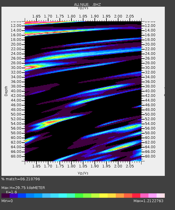
| Estimated Moho Depth: |
29.75 km |
| Estimated Crust Vp/Vs: |
1.60 |
| Assumed Crust Vp: |
4.24 km/s |
| Estimated Crust Vs: |
2.65 km/s |
| Estimated Crust Poisson's Ratio: |
0.18 |
|
| Radial Match: |
86.218796 % |
| Radial Bump: |
349 |
| Transverse Match: |
73.517715 % |
| Transverse Bump: |
400 |
| SOD ConfigId: |
434841 |
| Insert Time: |
2012-03-10 06:43:50.108 +0000 |
| GWidth: |
2.5 |
| Max Bumps: |
400 |
| Tol: |
0.001 |
|

Signal To Noise
| Channel | StoN | STA | LTA |
| AU:NIUE: :BHZ:20111214T05:12:18.319988Z | 6.340123 | 2.3088702E-5 | 3.6416805E-6 |
| AU:NIUE: :BHN:20111214T05:12:18.319988Z | 0.8899936 | 5.3227795E-6 | 5.980694E-6 |
| AU:NIUE: :BHE:20111214T05:12:18.319988Z | 6.176761 | 1.9384803E-5 | 3.1383443E-6 |
| Arrivals |
| Ps | 4.3 SECOND |
| PpPs | 18 SECOND |
| PsPs/PpSs | 22 SECOND |


