You are here: Home > Network List > CI - Caltech Regional Seismic Network Stations List
> Station LGU LGU, Camarillo, CA, USA > Earthquake Result Viewer
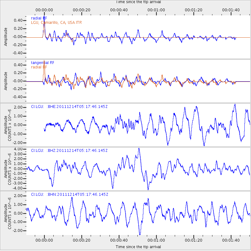
LGU LGU, Camarillo, CA, USA - Earthquake Result Viewer
*The percent match for this event was below the threshold and hence no stack was calculated.
| Earthquake location: |
Eastern New Guinea Reg., P.N.G. |
| Earthquake latitude/longitude: |
-7.6/146.8 |
| Earthquake time(UTC): |
2011/12/14 (348) 05:04:59 GMT |
| Earthquake Depth: |
141 km |
| Earthquake Magnitude: |
6.6 MB, 7.1 MW, 7.1 MW |
| Earthquake Catalog/Contributor: |
WHDF/NEIC |
|
| Network: |
CI Caltech Regional Seismic Network |
| Station: |
LGU LGU, Camarillo, CA, USA |
| Lat/Lon: |
34.11 N/119.07 W |
| Elevation: |
416 m |
|
| Distance: |
97.6 deg |
| Az: |
56.605 deg |
| Baz: |
266.031 deg |
| Ray Param: |
$rayparam |
*The percent match for this event was below the threshold and hence was not used in the summary stack. |
|
| Radial Match: |
79.35376 % |
| Radial Bump: |
395 |
| Transverse Match: |
54.698563 % |
| Transverse Bump: |
375 |
| SOD ConfigId: |
434841 |
| Insert Time: |
2012-03-10 06:45:46.005 +0000 |
| GWidth: |
2.5 |
| Max Bumps: |
400 |
| Tol: |
0.001 |
|
Signal To Noise
| Channel | StoN | STA | LTA |
| CI:LGU: :BHZ:20111214T05:17:46.145Z | 5.5407734 | 1.5877055E-6 | 2.8654944E-7 |
| CI:LGU: :BHN:20111214T05:17:46.145Z | 1.2095771 | 4.559708E-7 | 3.7696714E-7 |
| CI:LGU: :BHE:20111214T05:17:46.145Z | 1.088697 | 4.294522E-7 | 3.9446442E-7 |
| Arrivals |
| Ps | |
| PpPs | |
| PsPs/PpSs | |


