You are here: Home > Network List > MY - Malaysian National Seismic Network Stations List
> Station KKM Kota Kinabalu > Earthquake Result Viewer
KKM Kota Kinabalu - Earthquake Result Viewer
| Earthquake location: |
Eastern New Guinea Reg., P.N.G. |
| Earthquake latitude/longitude: |
-7.6/146.8 |
| Earthquake time(UTC): |
2011/12/14 (348) 05:04:59 GMT |
| Earthquake Depth: |
141 km |
| Earthquake Magnitude: |
6.6 MB, 7.1 MW, 7.1 MW |
| Earthquake Catalog/Contributor: |
WHDF/NEIC |
|
| Network: |
MY Malaysian National Seismic Network |
| Station: |
KKM Kota Kinabalu |
| Lat/Lon: |
6.04 N/116.21 E |
| Elevation: |
830 m |
|
| Distance: |
33.4 deg |
| Az: |
293.076 deg |
| Baz: |
113.491 deg |
| Ray Param: |
0.07781324 |
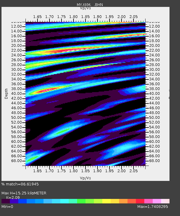
| Estimated Moho Depth: |
15.25 km |
| Estimated Crust Vp/Vs: |
2.09 |
| Assumed Crust Vp: |
6.048 km/s |
| Estimated Crust Vs: |
2.894 km/s |
| Estimated Crust Poisson's Ratio: |
0.35 |
|
| Radial Match: |
86.61945 % |
| Radial Bump: |
400 |
| Transverse Match: |
82.12674 % |
| Transverse Bump: |
400 |
| SOD ConfigId: |
434841 |
| Insert Time: |
2012-03-10 06:48:23.946 +0000 |
| GWidth: |
2.5 |
| Max Bumps: |
400 |
| Tol: |
0.001 |
|

Signal To Noise
| Channel | StoN | STA | LTA |
| MY:KKM: :BHZ:20111214T05:10:53.870006Z | 82.26052 | 1.8043218E-5 | 2.1934237E-7 |
| MY:KKM: :BHN:20111214T05:10:53.870006Z | 20.829689 | 6.79818E-6 | 3.2636973E-7 |
| MY:KKM: :BHE:20111214T05:10:53.870006Z | 38.3453 | 8.038384E-6 | 2.0963155E-7 |
| Arrivals |
| Ps | 2.9 SECOND |
| PpPs | 7.4 SECOND |
| PsPs/PpSs | 10 SECOND |


