You are here: Home > Network List > TA - USArray Transportable Network (new EarthScope stations) Stations List
> Station G05D Wamic, OR, USA > Earthquake Result Viewer
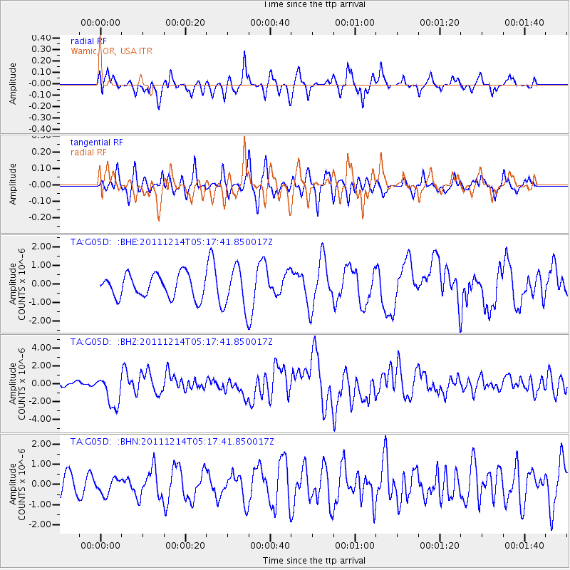
G05D Wamic, OR, USA - Earthquake Result Viewer
*The percent match for this event was below the threshold and hence no stack was calculated.
| Earthquake location: |
Eastern New Guinea Reg., P.N.G. |
| Earthquake latitude/longitude: |
-7.6/146.8 |
| Earthquake time(UTC): |
2011/12/14 (348) 05:04:59 GMT |
| Earthquake Depth: |
141 km |
| Earthquake Magnitude: |
6.6 MB, 7.1 MW, 7.1 MW |
| Earthquake Catalog/Contributor: |
WHDF/NEIC |
|
| Network: |
TA USArray Transportable Network (new EarthScope stations) |
| Station: |
G05D Wamic, OR, USA |
| Lat/Lon: |
45.24 N/121.32 W |
| Elevation: |
592 m |
|
| Distance: |
96.6 deg |
| Az: |
45.306 deg |
| Baz: |
265.997 deg |
| Ray Param: |
$rayparam |
*The percent match for this event was below the threshold and hence was not used in the summary stack. |
|
| Radial Match: |
52.319473 % |
| Radial Bump: |
350 |
| Transverse Match: |
51.68892 % |
| Transverse Bump: |
384 |
| SOD ConfigId: |
434841 |
| Insert Time: |
2012-03-10 06:49:41.121 +0000 |
| GWidth: |
2.5 |
| Max Bumps: |
400 |
| Tol: |
0.001 |
|
Signal To Noise
| Channel | StoN | STA | LTA |
| TA:G05D: :BHZ:20111214T05:17:41.850017Z | 6.989789 | 1.8150006E-6 | 2.5966457E-7 |
| TA:G05D: :BHN:20111214T05:17:41.850017Z | 0.73353076 | 3.9433223E-7 | 5.3758106E-7 |
| TA:G05D: :BHE:20111214T05:17:41.850017Z | 1.86342 | 1.1322558E-6 | 6.0762244E-7 |
| Arrivals |
| Ps | |
| PpPs | |
| PsPs/PpSs | |


