You are here: Home > Network List > TA - USArray Transportable Network (new EarthScope stations) Stations List
> Station O03D Paynes Creek, CA, USA > Earthquake Result Viewer
O03D Paynes Creek, CA, USA - Earthquake Result Viewer
| Earthquake location: |
Eastern New Guinea Reg., P.N.G. |
| Earthquake latitude/longitude: |
-7.6/146.8 |
| Earthquake time(UTC): |
2011/12/14 (348) 05:04:59 GMT |
| Earthquake Depth: |
141 km |
| Earthquake Magnitude: |
6.6 MB, 7.1 MW, 7.1 MW |
| Earthquake Catalog/Contributor: |
WHDF/NEIC |
|
| Network: |
TA USArray Transportable Network (new EarthScope stations) |
| Station: |
O03D Paynes Creek, CA, USA |
| Lat/Lon: |
40.29 N/121.80 W |
| Elevation: |
968 m |
|
| Distance: |
95.9 deg |
| Az: |
50.237 deg |
| Baz: |
265.13 deg |
| Ray Param: |
0.040556043 |
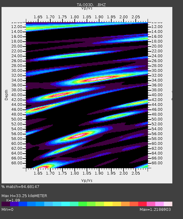
| Estimated Moho Depth: |
33.25 km |
| Estimated Crust Vp/Vs: |
1.89 |
| Assumed Crust Vp: |
6.566 km/s |
| Estimated Crust Vs: |
3.474 km/s |
| Estimated Crust Poisson's Ratio: |
0.31 |
|
| Radial Match: |
94.68147 % |
| Radial Bump: |
400 |
| Transverse Match: |
85.749306 % |
| Transverse Bump: |
400 |
| SOD ConfigId: |
434841 |
| Insert Time: |
2012-03-10 06:50:11.358 +0000 |
| GWidth: |
2.5 |
| Max Bumps: |
400 |
| Tol: |
0.001 |
|
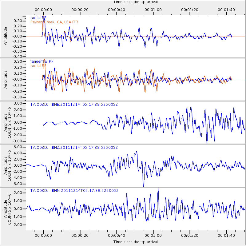
Signal To Noise
| Channel | StoN | STA | LTA |
| TA:O03D: :BHZ:20111214T05:17:38.525005Z | 11.98061 | 1.898828E-6 | 1.5849177E-7 |
| TA:O03D: :BHN:20111214T05:17:38.525005Z | 0.74726826 | 1.7229186E-7 | 2.3056226E-7 |
| TA:O03D: :BHE:20111214T05:17:38.525005Z | 3.8650553 | 5.758007E-7 | 1.4897606E-7 |
| Arrivals |
| Ps | 4.6 SECOND |
| PpPs | 14 SECOND |
| PsPs/PpSs | 19 SECOND |


