You are here: Home > Network List > UW - Pacific Northwest Regional Seismic Network Stations List
> Station LCCR Mulino, OR, USA > Earthquake Result Viewer
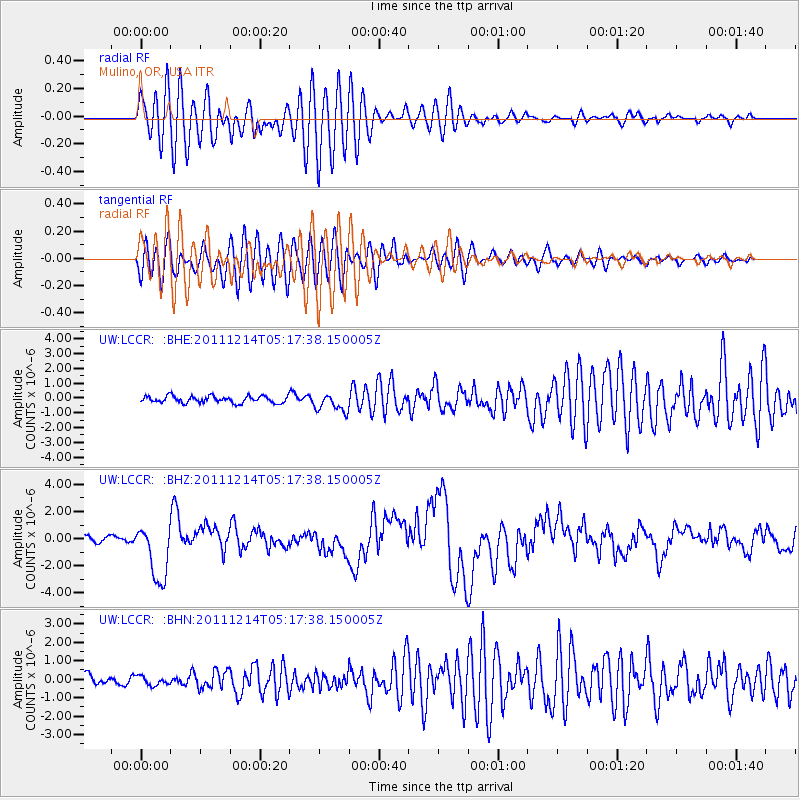
LCCR Mulino, OR, USA - Earthquake Result Viewer
*The percent match for this event was below the threshold and hence no stack was calculated.
| Earthquake location: |
Eastern New Guinea Reg., P.N.G. |
| Earthquake latitude/longitude: |
-7.6/146.8 |
| Earthquake time(UTC): |
2011/12/14 (348) 05:04:59 GMT |
| Earthquake Depth: |
141 km |
| Earthquake Magnitude: |
6.6 MB, 7.1 MW, 7.1 MW |
| Earthquake Catalog/Contributor: |
WHDF/NEIC |
|
| Network: |
UW Pacific Northwest Regional Seismic Network |
| Station: |
LCCR Mulino, OR, USA |
| Lat/Lon: |
45.21 N/122.48 W |
| Elevation: |
273 m |
|
| Distance: |
95.8 deg |
| Az: |
45.278 deg |
| Baz: |
265.178 deg |
| Ray Param: |
$rayparam |
*The percent match for this event was below the threshold and hence was not used in the summary stack. |
|
| Radial Match: |
75.99335 % |
| Radial Bump: |
400 |
| Transverse Match: |
74.035675 % |
| Transverse Bump: |
400 |
| SOD ConfigId: |
434841 |
| Insert Time: |
2012-03-10 06:53:28.014 +0000 |
| GWidth: |
2.5 |
| Max Bumps: |
400 |
| Tol: |
0.001 |
|
Signal To Noise
| Channel | StoN | STA | LTA |
| UW:LCCR: :BHZ:20111214T05:17:38.150005Z | 10.009091 | 2.137916E-6 | 2.135974E-7 |
| UW:LCCR: :BHN:20111214T05:17:38.150005Z | 1.0919676 | 2.437101E-7 | 2.2318436E-7 |
| UW:LCCR: :BHE:20111214T05:17:38.150005Z | 2.6828198 | 6.1824414E-7 | 2.3044566E-7 |
| Arrivals |
| Ps | |
| PpPs | |
| PsPs/PpSs | |


