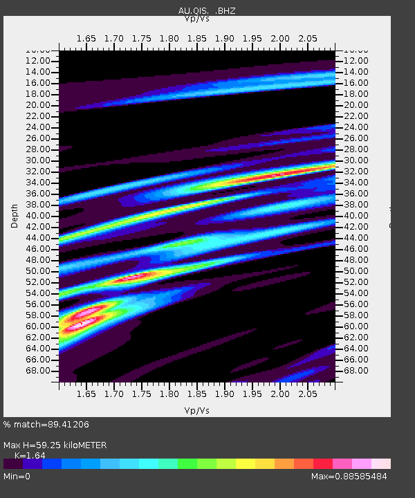
QIS Mount Isa, Queensland - Earthquake Result Viewer

Earthquake location: South Of Kermadec Islands
Earthquake latitude/longitude: -32.7/-179.1
Earthquake time(UTC): 2011/12/15 (349) 10:10:07 GMT
Earthquake Depth: 32 km
Earthquake Magnitude: 5.8 MB, 5.7 MS, 6.0 MW, 5.9 MW
Earthquake Catalog/Contributor: WHDF/NEIC
Network: AU Australian Seismological Centre
Station: QIS Mount Isa, Queensland
Lat/Lon: 20.56 S/139.61 E
Elevation: 450 m
Distance: 38.6 deg
Az: 277.777 deg
Baz: 116.962 deg
Ray Param: 0.07539523
Estimated Moho Depth: 59.25 km
Estimated Crust Vp/Vs: 1.64
Assumed Crust Vp: 6.577 km/s
Estimated Crust Vs: 4.01 km/s
Estimated Crust Poisson's Ratio: 0.20
Radial Match: 89.41206 %
Radial Bump: 349
Transverse Match: 88.815315 %
Transverse Bump: 379
SOD ConfigId: 434841
Insert Time: 2012-03-10 07:02:19.609 +0000
GWidth: 2.5
Max Bumps: 400
Tol: 0.001

Signal To Noise

ChannelStoNSTALTA
AU:QIS: :BHZ:20111215T10:16:56.97001Z8.9701168.235245E-79.1807564E-8
AU:QIS: :BHN:20111215T10:16:56.97001Z1.30030821.3605846E-71.04635554E-7
AU:QIS: :BHE:20111215T10:16:56.97001Z6.24107366.010681E-79.630845E-8
Arrivals
Ps6.3 SECOND
PpPs22 SECOND
PsPs/PpSs28 SECOND