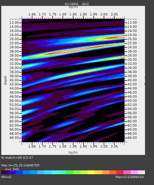
KNRA Kunnunarra, Western Australia - Earthquake Result Viewer

Earthquake location: South Of Kermadec Islands
Earthquake latitude/longitude: -32.7/-179.1
Earthquake time(UTC): 2011/12/15 (349) 10:10:07 GMT
Earthquake Depth: 32 km
Earthquake Magnitude: 5.8 MB, 5.7 MS, 6.0 MW, 5.9 MW
Earthquake Catalog/Contributor: WHDF/NEIC
Network: AU Australian Seismological Centre
Station: KNRA Kunnunarra, Western Australia
Lat/Lon: 15.68 S/128.76 E
Elevation: 101 m
Distance: 50.0 deg
Az: 276.873 deg
Baz: 119.676 deg
Ray Param: 0.06828649
Estimated Moho Depth: 25.25 km
Estimated Crust Vp/Vs: 1.85
Assumed Crust Vp: 6.397 km/s
Estimated Crust Vs: 3.467 km/s
Estimated Crust Poisson's Ratio: 0.29
Radial Match: 89.62147 %
Radial Bump: 400
Transverse Match: 79.32109 %
Transverse Bump: 400
SOD ConfigId: 434841
Insert Time: 2012-03-10 07:03:47.938 +0000
GWidth: 2.5
Max Bumps: 400
Tol: 0.001

Signal To Noise

ChannelStoNSTALTA
AU:KNRA: :BHZ:20111215T10:18:27.769998Z6.69917631.2363411E-61.845512E-7
AU:KNRA: :BHN:20111215T10:18:27.769998Z2.851693.0221491E-71.0597748E-7
AU:KNRA: :BHE:20111215T10:18:27.769998Z4.2258226.4476944E-71.5257848E-7
Arrivals
Ps3.5 SECOND
PpPs11 SECOND
PsPs/PpSs14 SECOND