You are here: Home > Network List > CI - Caltech Regional Seismic Network Stations List
> Station SWS Sam W. Stewart, Westmorland, CA, USA > Earthquake Result Viewer
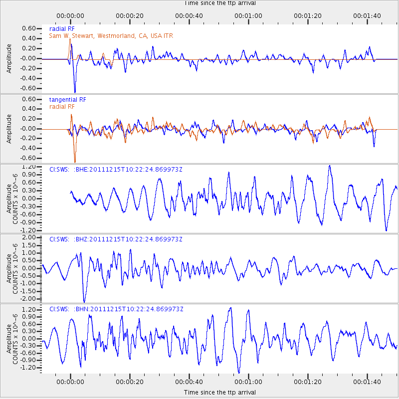
SWS Sam W. Stewart, Westmorland, CA, USA - Earthquake Result Viewer
*The percent match for this event was below the threshold and hence no stack was calculated.
| Earthquake location: |
South Of Kermadec Islands |
| Earthquake latitude/longitude: |
-32.7/-179.1 |
| Earthquake time(UTC): |
2011/12/15 (349) 10:10:07 GMT |
| Earthquake Depth: |
32 km |
| Earthquake Magnitude: |
5.8 MB, 5.7 MS, 6.0 MW, 5.9 MW |
| Earthquake Catalog/Contributor: |
WHDF/NEIC |
|
| Network: |
CI Caltech Regional Seismic Network |
| Station: |
SWS Sam W. Stewart, Westmorland, CA, USA |
| Lat/Lon: |
32.94 N/115.80 W |
| Elevation: |
140 m |
|
| Distance: |
88.4 deg |
| Az: |
48.723 deg |
| Baz: |
228.886 deg |
| Ray Param: |
$rayparam |
*The percent match for this event was below the threshold and hence was not used in the summary stack. |
|
| Radial Match: |
64.27286 % |
| Radial Bump: |
400 |
| Transverse Match: |
64.847374 % |
| Transverse Bump: |
400 |
| SOD ConfigId: |
434841 |
| Insert Time: |
2012-03-10 07:07:06.356 +0000 |
| GWidth: |
2.5 |
| Max Bumps: |
400 |
| Tol: |
0.001 |
|
Signal To Noise
| Channel | StoN | STA | LTA |
| CI:SWS: :BHZ:20111215T10:22:24.869973Z | 3.8703024 | 8.734959E-7 | 2.2569189E-7 |
| CI:SWS: :BHN:20111215T10:22:24.869973Z | 2.9200048 | 6.017675E-7 | 2.0608444E-7 |
| CI:SWS: :BHE:20111215T10:22:24.869973Z | 2.052107 | 4.959297E-7 | 2.4166854E-7 |
| Arrivals |
| Ps | |
| PpPs | |
| PsPs/PpSs | |


