You are here: Home > Network List > CI - Caltech Regional Seismic Network Stations List
> Station BFS Mt Baldy Forest Station > Earthquake Result Viewer
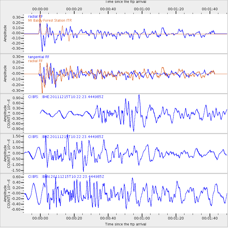
BFS Mt Baldy Forest Station - Earthquake Result Viewer
*The percent match for this event was below the threshold and hence no stack was calculated.
| Earthquake location: |
South Of Kermadec Islands |
| Earthquake latitude/longitude: |
-32.7/-179.1 |
| Earthquake time(UTC): |
2011/12/15 (349) 10:10:07 GMT |
| Earthquake Depth: |
32 km |
| Earthquake Magnitude: |
5.8 MB, 5.7 MS, 6.0 MW, 5.9 MW |
| Earthquake Catalog/Contributor: |
WHDF/NEIC |
|
| Network: |
CI Caltech Regional Seismic Network |
| Station: |
BFS Mt Baldy Forest Station |
| Lat/Lon: |
34.24 N/117.66 W |
| Elevation: |
1312 m |
|
| Distance: |
88.1 deg |
| Az: |
46.722 deg |
| Baz: |
227.8 deg |
| Ray Param: |
$rayparam |
*The percent match for this event was below the threshold and hence was not used in the summary stack. |
|
| Radial Match: |
75.29284 % |
| Radial Bump: |
400 |
| Transverse Match: |
72.57252 % |
| Transverse Bump: |
400 |
| SOD ConfigId: |
434841 |
| Insert Time: |
2012-03-10 07:08:29.825 +0000 |
| GWidth: |
2.5 |
| Max Bumps: |
400 |
| Tol: |
0.001 |
|
Signal To Noise
| Channel | StoN | STA | LTA |
| CI:BFS: :BHZ:20111215T10:22:23.444985Z | 4.9469376 | 6.080136E-7 | 1.2290705E-7 |
| CI:BFS: :BHN:20111215T10:22:23.444985Z | 2.185739 | 3.432737E-7 | 1.5705155E-7 |
| CI:BFS: :BHE:20111215T10:22:23.444985Z | 1.8335052 | 2.2035718E-7 | 1.2018356E-7 |
| Arrivals |
| Ps | |
| PpPs | |
| PsPs/PpSs | |


