You are here: Home > Network List > GT - Global Telemetered Seismograph Network (USAF/USGS) Stations List
> Station LPAZ La Paz , Bolivia > Earthquake Result Viewer
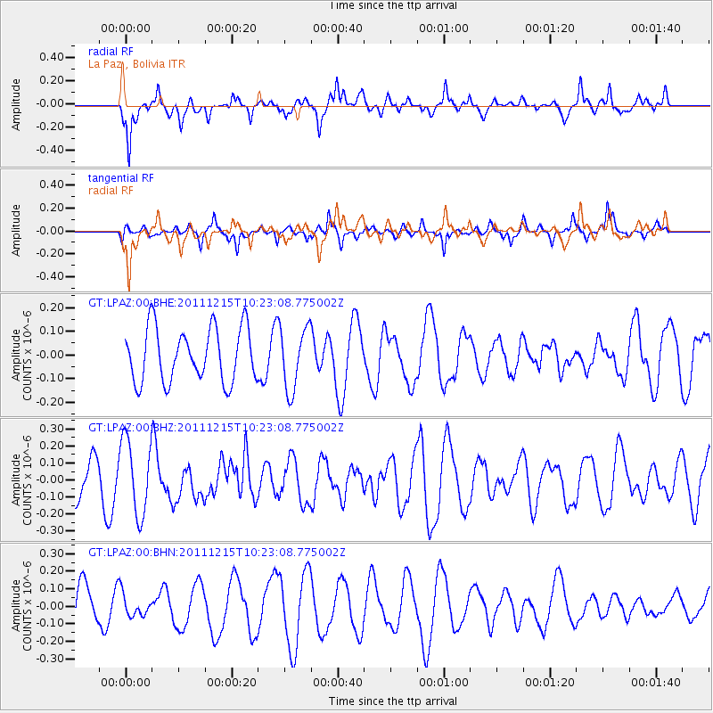
LPAZ La Paz , Bolivia - Earthquake Result Viewer
*The percent match for this event was below the threshold and hence no stack was calculated.
| Earthquake location: |
South Of Kermadec Islands |
| Earthquake latitude/longitude: |
-32.7/-179.1 |
| Earthquake time(UTC): |
2011/12/15 (349) 10:10:07 GMT |
| Earthquake Depth: |
32 km |
| Earthquake Magnitude: |
5.8 MB, 5.7 MS, 6.0 MW, 5.9 MW |
| Earthquake Catalog/Contributor: |
WHDF/NEIC |
|
| Network: |
GT Global Telemetered Seismograph Network (USAF/USGS) |
| Station: |
LPAZ La Paz , Bolivia |
| Lat/Lon: |
16.17 S/68.08 W |
| Elevation: |
4817 m |
|
| Distance: |
98.1 deg |
| Az: |
115.026 deg |
| Baz: |
232.646 deg |
| Ray Param: |
$rayparam |
*The percent match for this event was below the threshold and hence was not used in the summary stack. |
|
| Radial Match: |
63.16173 % |
| Radial Bump: |
400 |
| Transverse Match: |
49.101257 % |
| Transverse Bump: |
354 |
| SOD ConfigId: |
434841 |
| Insert Time: |
2012-03-10 07:09:47.741 +0000 |
| GWidth: |
2.5 |
| Max Bumps: |
400 |
| Tol: |
0.001 |
|
Signal To Noise
| Channel | StoN | STA | LTA |
| GT:LPAZ:00:BHZ:20111215T10:23:08.775002Z | 2.4902945 | 2.216355E-7 | 8.899971E-8 |
| GT:LPAZ:00:BHN:20111215T10:23:08.775002Z | 0.4410663 | 5.96942E-8 | 1.3534067E-7 |
| GT:LPAZ:00:BHE:20111215T10:23:08.775002Z | 1.1450738 | 1.3033372E-7 | 1.1382124E-7 |
| Arrivals |
| Ps | |
| PpPs | |
| PsPs/PpSs | |


