You are here: Home > Network List > IC - New China Digital Seismograph Network Stations List
> Station ENH Enshi, Hubei Province, China > Earthquake Result Viewer
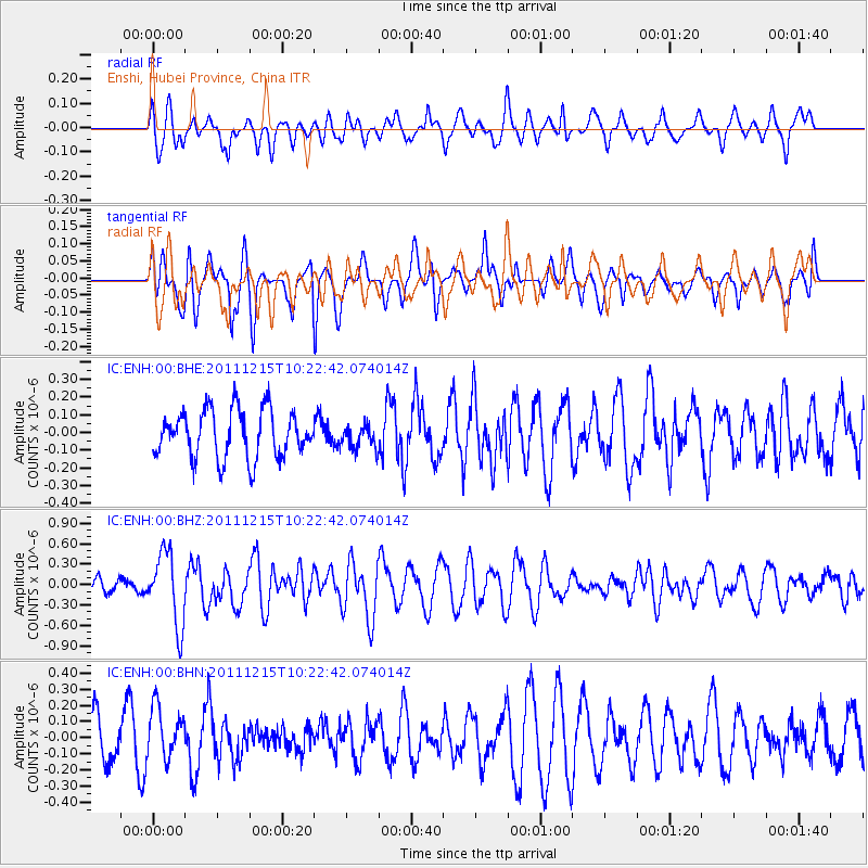
ENH Enshi, Hubei Province, China - Earthquake Result Viewer
*The percent match for this event was below the threshold and hence no stack was calculated.
| Earthquake location: |
South Of Kermadec Islands |
| Earthquake latitude/longitude: |
-32.7/-179.1 |
| Earthquake time(UTC): |
2011/12/15 (349) 10:10:07 GMT |
| Earthquake Depth: |
32 km |
| Earthquake Magnitude: |
5.8 MB, 5.7 MS, 6.0 MW, 5.9 MW |
| Earthquake Catalog/Contributor: |
WHDF/NEIC |
|
| Network: |
IC New China Digital Seismograph Network |
| Station: |
ENH Enshi, Hubei Province, China |
| Lat/Lon: |
30.28 N/109.49 E |
| Elevation: |
500 m |
|
| Distance: |
92.1 deg |
| Az: |
304.866 deg |
| Baz: |
126.913 deg |
| Ray Param: |
$rayparam |
*The percent match for this event was below the threshold and hence was not used in the summary stack. |
|
| Radial Match: |
61.288155 % |
| Radial Bump: |
400 |
| Transverse Match: |
57.772064 % |
| Transverse Bump: |
379 |
| SOD ConfigId: |
434841 |
| Insert Time: |
2012-03-10 07:09:53.986 +0000 |
| GWidth: |
2.5 |
| Max Bumps: |
400 |
| Tol: |
0.001 |
|
Signal To Noise
| Channel | StoN | STA | LTA |
| IC:ENH:00:BHZ:20111215T10:22:42.074014Z | 3.1474345 | 5.293345E-7 | 1.6817967E-7 |
| IC:ENH:00:BHN:20111215T10:22:42.074014Z | 1.1649075 | 1.5903876E-7 | 1.365248E-7 |
| IC:ENH:00:BHE:20111215T10:22:42.074014Z | 0.49123758 | 6.6142356E-8 | 1.3464434E-7 |
| Arrivals |
| Ps | |
| PpPs | |
| PsPs/PpSs | |


