You are here: Home > Network List > G - GEOSCOPE Stations List
> Station HYB Hyderabad, India > Earthquake Result Viewer
HYB Hyderabad, India - Earthquake Result Viewer

| Earthquake location: |
Sunda Strait, Indonesia |
| Earthquake latitude/longitude: |
-6.5/105.6 |
| Earthquake time(UTC): |
2000/10/25 (299) 09:32:23 GMT |
| Earthquake Depth: |
38 km |
| Earthquake Magnitude: |
6.3 MB, 6.6 MS, 6.8 MW, 6.7 ME |
| Earthquake Catalog/Contributor: |
WHDF/NEIC |
|
| Network: |
G GEOSCOPE |
| Station: |
HYB Hyderabad, India |
| Lat/Lon: |
17.42 N/78.55 E |
| Elevation: |
510 m |
|
| Distance: |
35.8 deg |
| Az: |
312.044 deg |
| Baz: |
129.39 deg |
| Ray Param: |
0.0769403 |
| Estimated Moho Depth: |
32.25 km |
| Estimated Crust Vp/Vs: |
1.74 |
| Assumed Crust Vp: |
6.459 km/s |
| Estimated Crust Vs: |
3.712 km/s |
| Estimated Crust Poisson's Ratio: |
0.25 |
|
| Radial Match: |
97.50641 % |
| Radial Bump: |
312 |
| Transverse Match: |
85.93983 % |
| Transverse Bump: |
400 |
| SOD ConfigId: |
3744 |
| Insert Time: |
2010-02-26 22:59:57.909 +0000 |
| GWidth: |
2.5 |
| Max Bumps: |
400 |
| Tol: |
0.001 |
|
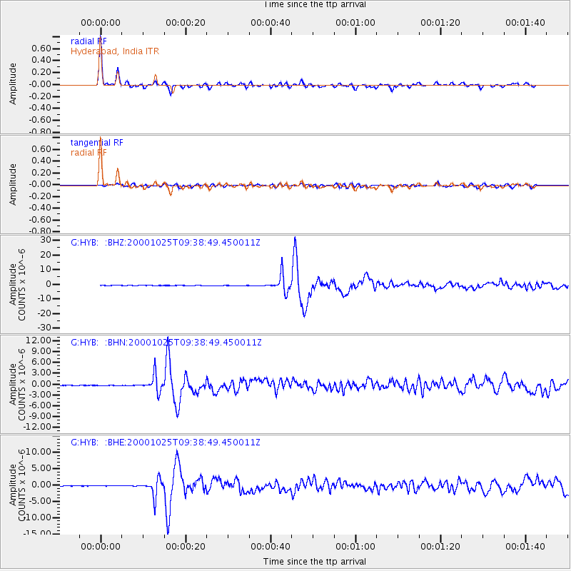
Signal To Noise
| Channel | StoN | STA | LTA |
| G:HYB: :BHN:20001025T09:38:49.450011Z | 2.0059645 | 7.760322E-8 | 3.8686235E-8 |
| G:HYB: :BHE:20001025T09:38:49.450011Z | 1.2990738 | 6.6420725E-8 | 5.112929E-8 |
| G:HYB: :BHZ:20001025T09:38:49.450011Z | 1.3223815 | 9.598516E-8 | 7.2585074E-8 |
| Arrivals |
| Ps | 4.0 SECOND |
| PpPs | 13 SECOND |
| PsPs/PpSs | 17 SECOND |


