You are here: Home > Network List > AZ - ANZA Regional Network Stations List
> Station SMER AZ.SMER > Earthquake Result Viewer
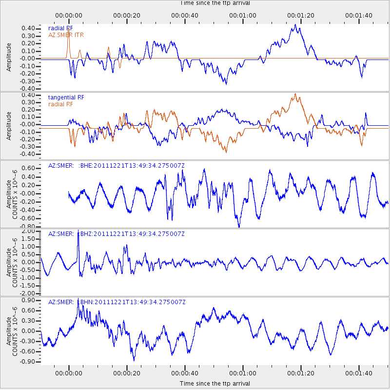
SMER AZ.SMER - Earthquake Result Viewer
*The percent match for this event was below the threshold and hence no stack was calculated.
| Earthquake location: |
South Of Kermadec Islands |
| Earthquake latitude/longitude: |
-33.2/-179.0 |
| Earthquake time(UTC): |
2011/12/21 (355) 13:37:14 GMT |
| Earthquake Depth: |
10 km |
| Earthquake Magnitude: |
5.6 MB, 5.4 MS, 5.5 MW, 5.7 MW |
| Earthquake Catalog/Contributor: |
WHDF/NEIC |
|
| Network: |
AZ ANZA Regional Network |
| Station: |
SMER AZ.SMER |
| Lat/Lon: |
33.46 N/117.17 W |
| Elevation: |
355 m |
|
| Distance: |
88.2 deg |
| Az: |
47.515 deg |
| Baz: |
227.721 deg |
| Ray Param: |
$rayparam |
*The percent match for this event was below the threshold and hence was not used in the summary stack. |
|
| Radial Match: |
58.378708 % |
| Radial Bump: |
400 |
| Transverse Match: |
51.49335 % |
| Transverse Bump: |
400 |
| SOD ConfigId: |
434841 |
| Insert Time: |
2012-03-13 20:47:02.322 +0000 |
| GWidth: |
2.5 |
| Max Bumps: |
400 |
| Tol: |
0.001 |
|
Signal To Noise
| Channel | StoN | STA | LTA |
| AZ:SMER: :BHZ:20111221T13:49:34.275007Z | 1.6775515 | 6.460517E-7 | 3.8511587E-7 |
| AZ:SMER: :BHN:20111221T13:49:34.275007Z | 2.6806126 | 4.5720162E-7 | 1.7055864E-7 |
| AZ:SMER: :BHE:20111221T13:49:34.275007Z | 1.7678478 | 3.057451E-7 | 1.7294762E-7 |
| Arrivals |
| Ps | |
| PpPs | |
| PsPs/PpSs | |


